Laverty Falls Trail
Gallery

Store

Quick Facts
| Difficulty | moderate |
| Trail Type | linear |
| Distance | 2.5 km |
| Estimated Time | 1 hr |
| Surface Type | forested |
| Elevation Change | 149 metres |
| Features | waterfall |
| Trail Markers | yellow hiking symbols |
| Scenery Rating | must see |
| Maintenance Rating | well maintained |
| Cell Reception | none |
| Dog Friendly | on a leash |
| Fees | yes |
Description
The trail to Laverty Falls starts from a little field off the end of the parking lot. The Moosehorn Trail and Forks Trail start to the right. The Laverty Falls Trail and Moosehorn Trail form a loop that descend to Broad River, then follows the river for about 2 km before climbing out of the river valley. We prefer to start the loop on the Moosehorn Trail.
The Laverty Falls Trail provides a slow descent to Laverty Falls. Most of the trail travels through an old hardwood forest with many smaller hardwoods underneath. There are several very large birch and maple, some of which are hollow and are being used by local wildlife. There are several wet spots on the trail that are easily crossed using roots and small rocks. When you get nearer to the river the forest transitions into a spruce dominated forest type. Eventually you will come to a small rocky outcrop. You should be able to hear the falls from here. The trail goes right up and through the middle of the outcrop and emerges at the top of the falls.

The trail loops down around to the bottom of the falls. The waterfall is a curtain falls and comes out through the rocky outcrop and drops over an angled rock face. I found that the angled rock made it difficult to take a level picture of the falls without looking tilted but it's a beautiful set of falls and very photogenic.
After you get your fill of pictures, and maybe take a swim, you can continue on the trail down along the river. After a short distance (about 200 metres) you will come to junction in the trail. The trail that crosses the river to the left is the Dobson Trail. This is a 58 km trail that goes all the way to the Town of Riverview. The other trail that continues along the river is the Moosehorn Trail. At this point you can return to the parking lot the way you came or continue on the Moosehorn Trail, which provides a more strenuous but more interesting loop back to the parking lot.
Map

From the Sign
Laverty Falls Trail
Hike through a wonderful hardwood stand of maple, birch, beech to the Laverty Falls. You can view this beautiful curtain waterfall from above or below.
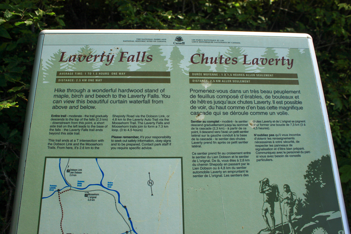
The trail gradually descends to the top of the falls (2.3 km) - downstream from this point, a short side trail on the left leads to the base of the falls - the Laverty Falls trail ends beyond this side trail.
The trail ends at a T intersection with the Dobson Link and Moosehorn Trails. From here, it's 2.6 km to the Shepody Road via the Dobson Link, or 4.8 km to the Laverty Road via the Moosehorn Trail. The Laverty Falls and Moosehorn trails join to form a 7.3 km loop. (3 to 4.5 hours)
Please remember, it's your responsibility to seek out safety information, obey signs and to be prepared. Contact park staff if you require specific advice.
Directions
For directions to the park go to the Fundy National Park page.
From the northern entrance at Wolfe Lake travel 11.7 km south, then turn left onto the Laverty Auto Trail. If you are entering the park from the eastern gate in Alma climb the hill. When you come to a roundabout in front of the visitor center keep right and continue on Route 114. After 7.9 km from the gate turn right onto the Laverty Auto Trail.
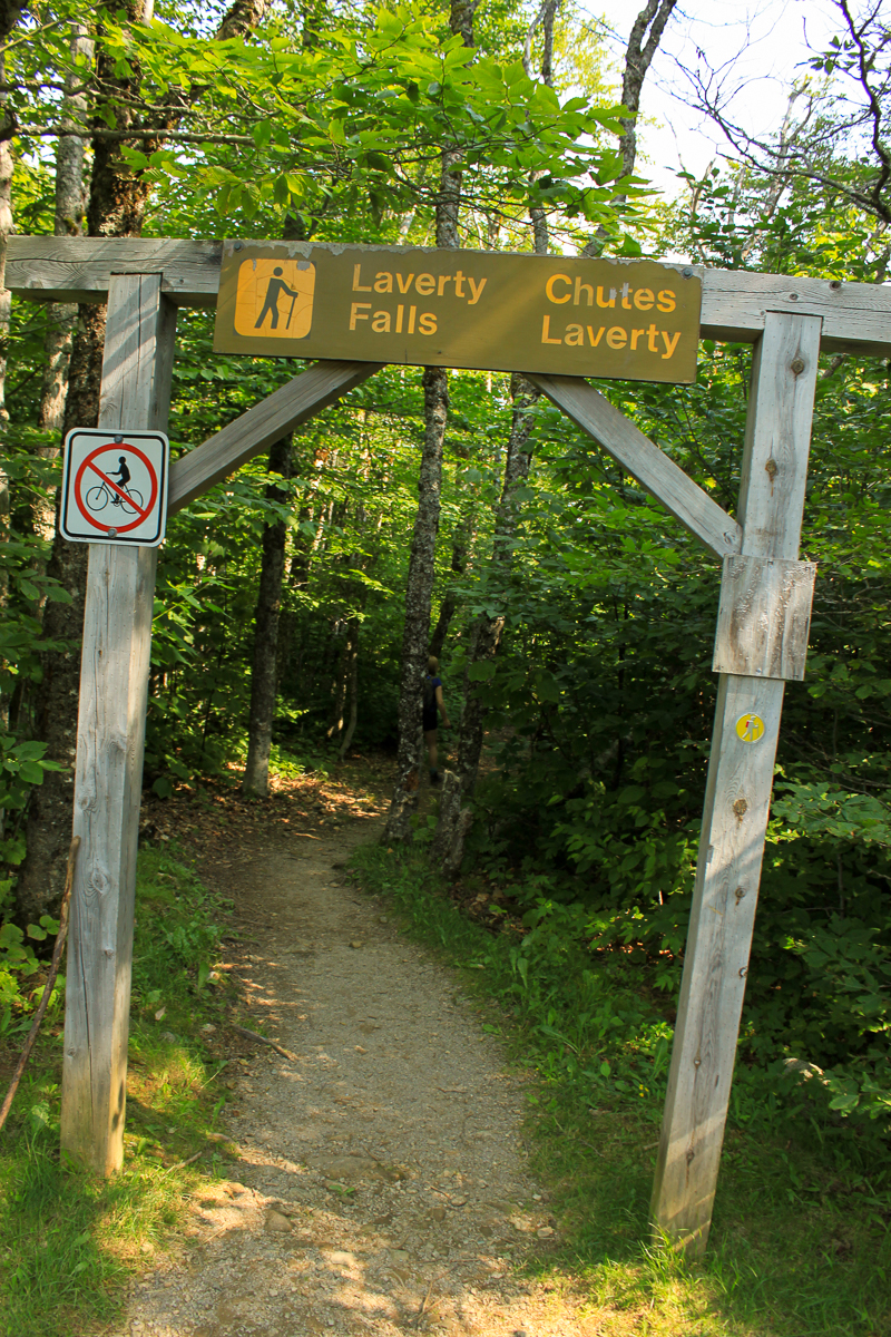
The Laverty Auto Trail is a gravel road but it is usually in really good shape for cars. After 5 km, and passing the Tracey Lake Trail on your left, you will take a sharp turn to the right. After another 1.5 km you will come to a parking lot. The Laverty Falls, Moosehorn, and Forks Trails start from the small field off the end of the parking lot.

Other Trails in the Park
- Bennett Brook Trail
- Black Hole Trail
- Black Horse Trail
- Caribou Plain Trail
- Coastal Trail
- Coppermine Trail
- Dobson Link
- Dickson Falls Trail
- East Branch Trail
- Foster Brook Trail
- Goose River Trail
- Herring Cove Beach
- Kinnie Brook Trail
- Marven Lake Trail
- Matthews Head Trail
- Maple Grove Trail
- Moosehorn Trail
- Point Wolfe Beach Trail
- Shiphaven Trail
- The Forks Trail
- Third Vault Falls Trail
- Tippen Lot Trail
- Tracey Lake Trail
- Upper Salmon River Trail
- Whitetail Trail
Trail Last Hiked: August 6, 2022.
Page Last Updated: November 18, 2022.