Pot Rock Scenic Footpath
Gallery

Store
Quick Facts
| Difficulty | easy |
| Trail Type | linear |
| Distance | 1.4 km one way |
| Estimated Time | 1 hour return |
| Surface Type | forested |
| Elevation Change | 24 meters |
| Features | pot rock, coastal views |
| Trail Markers | signs |
| Scenery Rating | must see |
| Maintenance Rating | well maintained |
| Cell Reception | medium |
| Dog Friendly | on a leash |
| Fees | yes |
Description
The Pot Rock Scenic Footpath is a short trail that loops down around the cliff tops along the Bay of Fundy. The best way to hike this trail is to make it a loop by returning on the Multi Use Trail. If you start the trail by descending the stairs at the Fownes Head Lookout, turn left on the Multi Use Trail when you get to the end.
Once you drop down over the first hill the trail is relatively flat. Around the Pot Rocks there are several lookouts that provide views of the Pot Rocks. The best is the one furthest to the south near the bottom of the hill. It gives great views of the Pot Rock below and the rugged Fundy Coast.
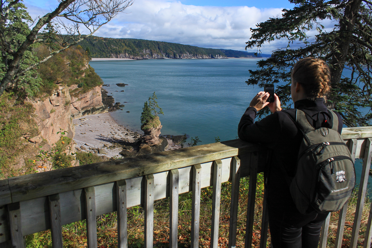
The Pot Rock is a tall sandstone rock that has been eroded at the base by the amazing Fundy Tides (if you don't already know they are the highest tides in the world). The rock has several relatively large trees clinging to its top.
There can be wet sections along the trail at certain times of year. A good pair of boots are helpful but not necessary. When I hiked this at night to get the last picture in the gallery there were several large porcupines eating beside the lookout. I met another one bumbling down the trail not far away.
Map

Directions
For directions to the park go to the Fundy Trail Provincial Park page.
From the west gate nearest St. Martins drive 1.8 kilometre and then turn left into parking lot P2. Park and then cross back over the road to the Fownes Head Lookout, just across from where you entered the parking lot. From here you will see the start of the Pot Rock Scenic Footpath descending a set of stairs. If you make it a loop you will return on the Multi Use Trail that passes by the lookout.

From the Sign
Geological Ages for this Site
Red rocks of the Echo Cove Formation along the Fundy Trail Parkway are Triassic age, about 250 million years old. They tell the story of the birth of the Atlantic Ocean, a relatively recent geological feature only about 200 million years old. Seafloor spreading created it. Molten rock from the Earth's interior rises to the surface to create new crust. A 'bubble' forms in the crust that eventually breaks to create rift valleys. As magma rises and cools the new crust expands to create volcanic mountain chains along the rift valleys that mark the middle of an expanding ocean basin. The Bay of Fundy occupies one of the many rifts created as the Atlantic Ocean opened.

Rocks are eroded by the action of water slowly breaking down the layers into smaller pieces. The sand and mud will be washed out into the Bay of Fundy, recycled to once again become sedimentary rocks. 'Flower pots' are a picturesque result of coastal erosion. They are fragments of the eroding coastline that have withstood the pounding of the sea. They remind us where the coastline once stood. Someday they will succumb to the sea.
Other Trails in the Park
- Big Salmon River Beach Loop
- Big Salmon River Cemetery Footpath
- Bradshaw Lookout Scenic Footpath
- Cranberry Brook Loop
- Fuller Falls Trail
- Hearst Lodge Historic Footpath
- Long Beach Brook Waterfall Trail
- McCumber Brook Wetlands Trail
- McCumber Brook Access Trail to the Fundy Footpath
- McLeod Brook Falls Trail
- Melvin Beach Trail
- Multi Use Trail
- Sea Captains' Burial Grounds Trail
- Seely Beach Access Trail
- Walton Glen Gorge Lookout Trail

Trail Last Hiked: October 19, 2018.
Page Last Updated: December 21, 2019.