Mount Carleton Trail
Video
Store

Quick Facts
| Difficulty | strenuous |
| Trail Type | loop |
| Distance | 9.3 km |
| Estimated Time | 3 to 4 hours |
| Surface Type | forest, rock |
| Elevation Change | 412 meters |
| Features | peak, fire tower |
| Trail Markers | green squares |
| Scenery Rating | must see |
| Maintenance Rating | well maintained |
| Cell Reception | minimal |
| Dog Friendly | on a leash |
| Fees | park entrance - cash only |
Map
Gallery

From the Sign
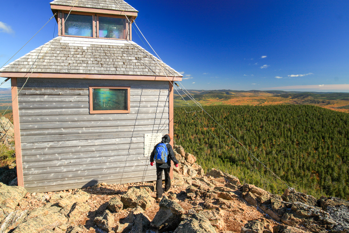
A TOWERMAN'S LIFE
This was home to the men who operated the firetower perched on Mount Carletons' peak. The towermen would arrive by May 15th to watch during the fire season, which lasted into October. When the program started in 1923 there was only one towerman for many years, Mr. John Hanna. Then because of safety and isolation two went on duty and later when radios were improved, it returned to one operator.
The tower was no longer manned after 1968 when airplanes began to be used for patroling. Today infra-red detectors that can spot fires through clouds, lightweight-powerful radios, high speed pumps, fire bombers using water and fire retarding chemicals and helicopters are all available for fighting forest fires. Of course Smokey the Bear is still helping by reminding "Only YOU can prevent forest firest."
Nighttimes and some rainy or cloudy days the men would be around this cabin, or another that was near the parking lot, with books, hobbies and the local animals for company. Most other times, the towerman would be scanning the forest for smoke from the glassed-in top of the tower. In the center of the floor on top of a tall round table was a map of the area he could see. If he spotted smoke he could turn the alidade, brass lighting device over the map, until it was lined up on the fire. Then using his crank telephone (or radio after the 1950's) he would call headquarters with an estimated distance and the exact bearing. As other towermen reported, the rangers drew lines on a map from each tower location and pinpointed the fire- the spot where the lines crossed.

The towermen kept busy on rainy days or while the other man was on duty by maintaining the telephone line or working on roads and trails leading to the tower. During hot times, when the towermen could not leave the tower, other men would do those jobs as well as bring in supplies, news, etc. If it was a wet spell and two were on duty then they woul take turns heading out to civilization and family, then returning with supplies.
From the Sign
A LOOK-OUT FOR FOREST FIRE DETECTION
This fire cabin was built in 1923. From spring until fall, this cabin and the one along the trail were both home and workplace for two fire rangers. The rangers were responsible for twice daily weather readings and a continual fire watch. They took turns scanning the horizon with binoculars. On a clear day, they could spot smoke from fires up to 65 km away.
THERE'S SMOKE!
At the first sign of smoke, a ranger would determine the angle of the fire from the cabin's position on the map. The other man would use the crank telephone to immediately notify the fire warden at Plaster Rock. Reports from other towers would help the warden pinpoint the fire's exact location.
REPLACED BY AIRPLANE PATROLS
This cabin served as a look-out for fire rangers for 45 years. By 1968, the cabin's days as a vital link in a forest fire detection network were over. New Brunswick began using airplane patrols instead of tower watches to detect forest fires.
Today, the cabin in enjoyed for the majestic view it offers. It also stands a a historical monument to past methods of forest fire detection in New Brunswick
Description
The eastern section of the loop trail travels around the parking area in the woods along the top. Continue on this trail and you will cross a hardwood stand eventually coming to Mamozekal Stream. The trail turns sharply to the right and follows this beautiful, mossy stream up the mountain.
The hardwood thins out and becomes more sparse near the top. The trail passes by the headwaters campsites after leaving the stream edge. There is an outhouse at the campsites but it's not in great shape. The trail continues and comes to a trail junction at the base of a rocky ridge. Turning left will take you through the woods along the bottom of the ridge and is what should be used during inclement weather. Go straight and you will start to climb up to the ridge.
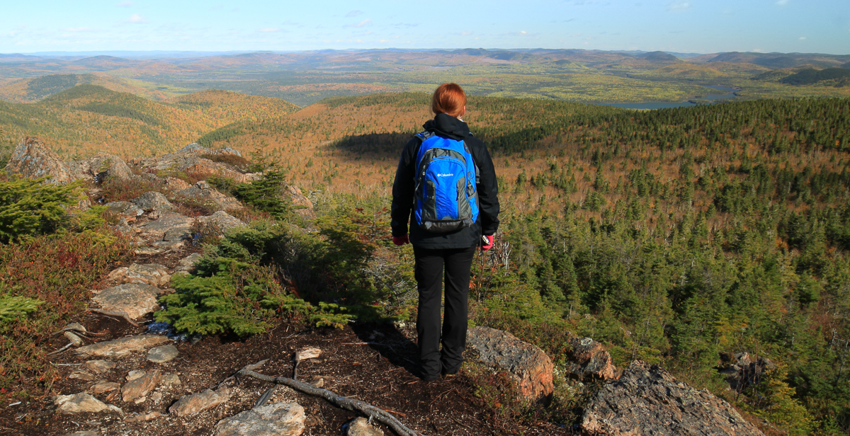
The climb up to the first ridge is steep and a bit of a scramble but not too difficult. When you emerge onto the first ridge you will be treated with views of the main ridge and the fire tower at the peak. Climb down through a small patch of trees and then climb up onto the main ridge. The views from the main ridge are spectacular in every direction.
After crossing the main ridge you will come to the fire tower that marks the peak. This tower was used by men in the early 1900's to look for wildfires (see From the Sign section below). The tower or the surrounding rocks are a perfect place to have lunch.
Continue past the fire tower and to the right the trail starts to descend down into the forest below. At the bottom of the ridge there is an opening that marks the entrance to the Mount Head Trail. From this small opening the trail turns into an old road that is more like an ATV trail with loose gravel. About a third of the way down the mountain you will find a cabin that used to be used by the fire tower men when they weren't at the peak.
Trail Last Hiked: October 13, 2024.
Page Last Updated: December 14, 2025.
Directions
For directions to the park go to the Mount Carleton Park page.
From the front gate drive for 5.3 kilometres, passing by the group campground and traveling along Nictau Lake. At 5.3 kilometres turn right. Drive for 7.9 kilometres and you will come to a parking area. The trailhead is just off the end of the road near the parking area.