Melvin Beach Trail
Gallery
Store
Quick Facts
| Difficulty | moderate |
| Trail Type | linear |
| Distance | 0.2 km one way |
| Estimated Time | 20 mins |
| Surface Type | wooden stairs |
| Elevation Change | 18 meters |
| Features | waterfall, caves, beach |
| Trail Markers | signs |
| Scenery Rating | must see |
| Maintenance Rating | well maintained |
| Cell Reception | variable |
| Dog Friendly | on a leash |
| Fees | yes |
Directions
For directions to the Fundy Trail Provincial Park go to the Fundy Trail Provincial Park page.
Travel 1.8 km from the west park gate and you will see the P2 parking area on your left. Park in this parking lot and use the trail near the middle of the parking lot to cross the road. You can also park at the Melvin Beach Lookout on the right but there is not many spaces so they should be left for people stopping for a shorter period of time. Once you are on the Multi Use Trail in front of the lookout turn left. After 540 meters and several steep switch-back descents on the hard packed trail you will cross a bridge and then come to the Melvin Beach trail on your right.
Another way to access the Melvin Beach Trail is to continue past P2 for another 1 km where you will find the parking area for Bradshaw Lookout. The Bradshaw Lookout Scenic Footpath follows a stream down over the hill. There is another trail that crosses the stream to the left about half way down but stay straight. The trail will eventually come out on the Multi-Use Trail. Turn left and cross the bridge and you will find the Melvin Beach Trail on the right.
Map

Description
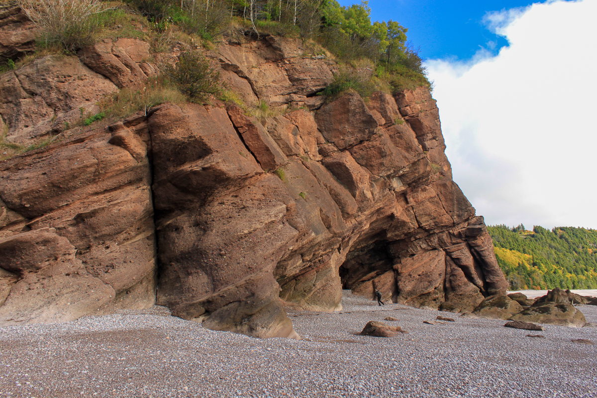
The Melvin Beach Trail is a short trail that leads to a long set of stairs that descend to the beach. There is then a small trail that follows Fuller Stream to the left to where you can cross the stream without getting wet. If you continue up the stream into the small valley you will find Lower Fuller Falls. This is an impressive set of falls that come out over the large rocks that make up the stream bed.

If you cross the stream and climb the gravel beach you will get an expansive view of the Bay of Fundy. The cliffs and sea cave to the left, along with the large rocks that have fallen off the cliff face and embedded themselves into the beach, are an interesting place to begin exploring. Pangburn beach extends for almost a kilometer in a straight line on the other side of the cliff and rocks . You may not be able to access the caves and Pangburn Beach at high tide but there are still many areas to explore. The beach is made up of round rocks but they are not large enough to make it a hazard for walking.

Other Trails in the Park
- Big Salmon River Beach Loop
- Big Salmon River Cemetery Footpath
- Bradshaw Lookout Scenic Footpath
- Cranberry Brook Loop
- Fuller Falls Trail
- Hearst Lodge Historic Footpath
- Long Beach Brook Waterfall Trail
- McCumber Brook Wetlands Trail
- McCumber Brook Access Trail to the Fundy Footpath
- McLeod Brook Falls Trail
- Multi Use Trail
- Pot Rock Scenic Footpath
- Sea Captains' Burial Grounds Trail
- Seely Beach Access Trail
- Walton Glen Gorge Lookout Trail
Trail Last Hiked: October 19, 2018.
Page Last Updated: March 7, 2020.