Portage Trail
Videos
Quick Facts
| Difficulty | easy |
| Trail Type | linear |
| Distance | 4.1 km |
| Estimated Time | 1 hr 30 mins one way |
| Surface Type | forested, boardwalk |
| Elevation Change | 72 meters |
| Features | lakes, forest |
| Trail Markers | yellow diamonds |
| Scenery Rating | beautiful |
| Maintenance Rating | well maintained |
| Cell Reception | none |
| Dog Friendly | on a leash |
| Fees | park entrance - cash only |
Gallery

Directions
For directions to the park go to the Mount Carleton Park page.
There are several access points to this trail. From the park entrance travel 1 km on the main park road then turn left towards the Armstrong Campground. Travel 9 km on this road and you will come to a side road on the right. At 200 meters on this road you will come to bridges over the ditches where the trail crosses the road.

Continue past the side road for another 1.3 km and you will cross a small bridge. The trail uses the bridge to cross the stream and enters the woods on the right on either side of the bridge.
Continue another 1.3 km past the bridge you you will come to a small parking area with a sign on your right. The sign is about portage trails. An access trail enters the woods to the right of the sign.
The final and best place to access this trail is at the access road to Bathurst lake. Another 400 meters past the small parking area you will see a small loop road on the right. Park around this loop. You can access the road to Bathurst lake behind the gate at the back of the loop. Follow the access road for 150 meters (about half way to the lake) and you will find the end of the Portage Trail enter the woods on your right.
Map
Store

Description
The recently reclaimed Portage Trail (summer 2016) was an ancient travel corridor between Little Nictau Lake and Bathurst Lake. Thousands of years ago First Nations people carried their canoes through these woods to access other waterways in the region from the Nepisiguit River system. The trail follows the flattest route between the two lakes making this one of the easist trails in the park.
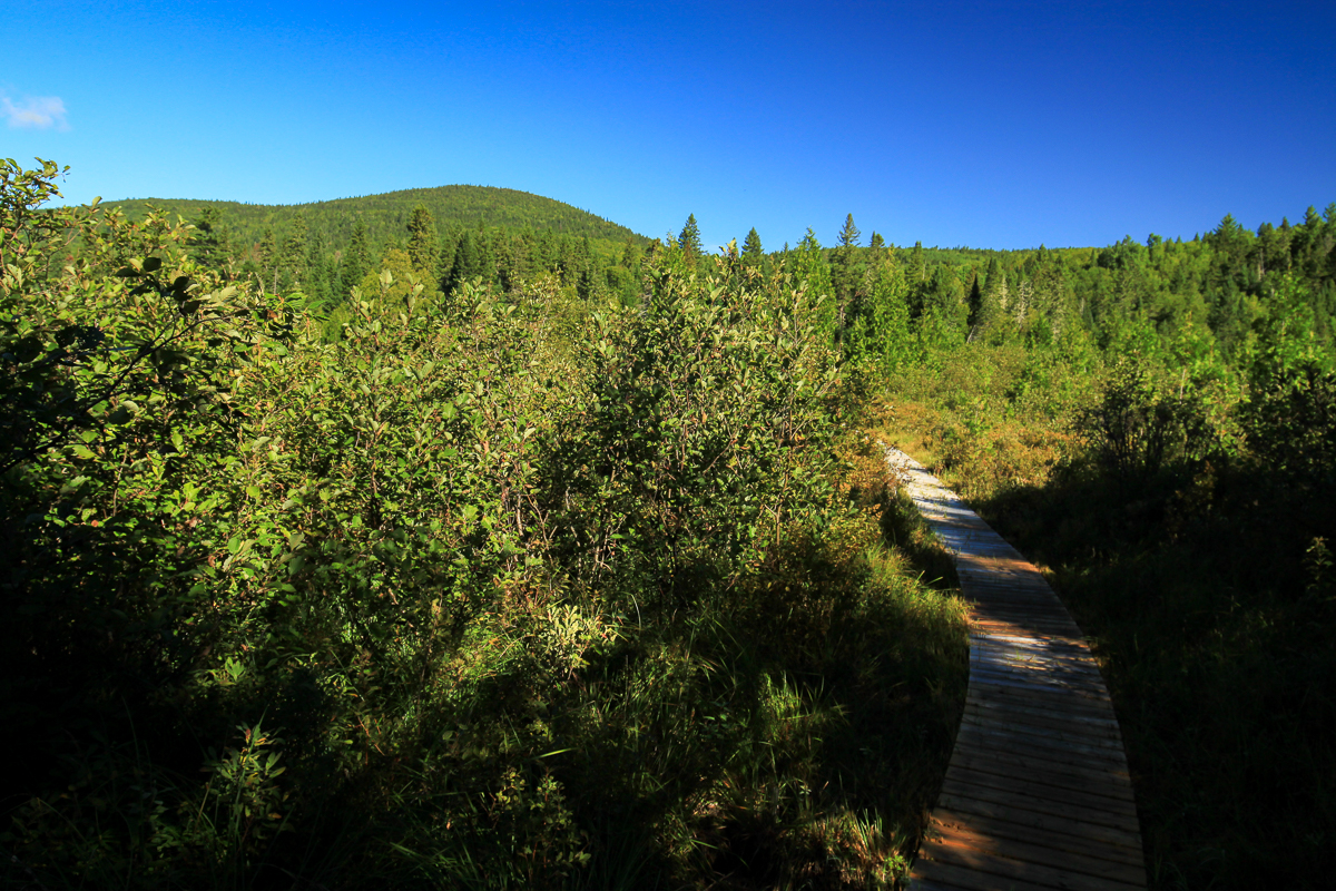
The Bathurst Lake end of the trail travels through a mixedwood forest. There are several places along the trail where a board has been put between two trees at eye-level. This is so people portaging can rest their canoe without putting it down.
Once the trail gets close to Little Nictua lake it dips down into a wet, moss laden, spruce forest. There are several sections of boardwalk in this area to help keep you dry. One boardwalk ends at the shallow, easternmost section of the lake.
If you are hiking this trail you can make a loop by returning on the Caribou Brook Trail. To get to the Caribou Brook Trail follow the crossover road (road nearest Little Nictau Lake) to the Mount Sagamook Trail. It is 2.5 km between the two trails.
From the Sign
THE GLACIAL MORRAINE - A WATERSHED DIVIDE
Glaciers scraped the tops from the ancient volcanic mountains, pulverized the pieces into boulders and gravel then retreated leaving rounded mountains and long ridges of gravel. You are on top of a "morraine" of gravel separating the Nictau and Nepisiguit Lakes. It forms part of a long crest called a "watershed divide". Water to your right flows west to the Saint John River, to the left it heads east down the Nepisiguit. If you were to use some buckets of water to test it - all you would notice is how quickly the water soaks into the ground. Water flows easily through the gravel morraine, in fact just down the hill "Dry Brook" flows underground using the dry stream bed only during spring runoff. Take a walk about 300 metres up the dry streambed and you will notice a small flow of water disappearing into the rocks, then in an amazingly short distance upstream, a full brook.

For hundreds, perhaps even thousands of years, this crest has been reached with a sigh of relief by canoe portagers. Indians, explorers, missionaries, trappers and fishermen all used the rivers and lakes as highways and this is the highest point of a 3 kilometer portage between the Saint John and Nepisiguit river systems. The path has been the scene of hardship and tragedy - in 1623 a missionary, Father Joseph Bernadin Sebastin was ambushed and killed by Indians as he portaged towards the Saint John River.
From the Sign
MT. SAGAMOOK
Millions of years ago a steaming volcano stood here. Then, during the last million years, glaciers 3 kilometres thick scraped over the peak reducing it to a "monadnock" or rounded mountain topped with rock outcrops. The highest outcrops became known as Mount Carleton, Mount Head and Mount Sagamook.

The glaciers also pushed around the ground and rubble forming hills and a ridge nearby which plugged the valley between the Nictau and Nepisiguit Lakes. The water was forced to reverse its flow and carve a new route, the Nepisiguit River. The coating of rubble left on the slopes of Mount Sagamook rumbled down in a series of landslides about 10,000 years ago. The slides, visible from the lakeshore roads, are walked across while hiking up the mountain.
Forest fires have drastically changed the forest upon the crests and sides of these mountains. Look up. Any patch of dark green (spruce and fir trees) is a place that was not scorched in the 1923 and 1933 fires. The burned areas are now covered with hardwood trees (birches, maples) whose seeds were light enough to be blown far across the vast wasteland. Both forest types are home to a variety of wildlife including bear, deer, squirrels and numerous musical birds such as the Veery and Wood Thrush.

Trail Last Hiked: September 10, 2016.
Page Last Updated: April 6, 2020.