Fundy Footpath
Galleries
Map
Quick Facts
| Difficulty | strenuous |
| Trail Type | linear |
| Distance | 11.7 km one way |
| Estimated Time | 1 day |
| Surface Type | forested, beach |
| Elevation Change | 192 meters |
| Features | coastal views, waterfall |
| Trail Markers | white blazes |
| Scenery Rating | must-see |
| Maintenance Rating | well maintained |
| Cell Reception | variable |
| Dog Friendly | yes |
| Fees | park access |
Description
The Quiddy River to Little Salmon River section of the Fundy Footpath starts at Quiddy River. Next to the river there is a campsite on a flat, sandy spot surrounded by hardwoods. The trail climbs the hill up out of the Quiddy River valley with many switchbacks. Once at the top of the hill the trail is relatively flat for more than a kilometer.
The trail travels through a mixed forest and passes several ATV Trails that I am assuming make their way to Martin Head. Near a small stream there is a fire pit with several old tin pails that have probably been there for many years. There is a beautiful view of the coast to the west before the trail drops down to Telegraph Brook.
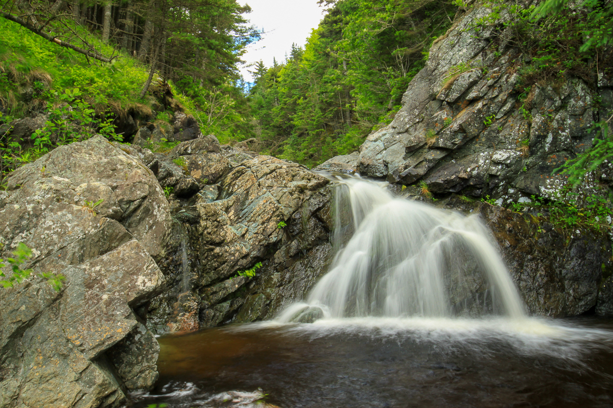
A small 6 foot waterfall on Telegraph Brook drops into a pool near the shore. The Telegraph Brook campsite is on a patch of gravel next to this pool. The campsite has a bear box and an outhouse. On the other side of the campsite is the beach, which drops off towards the bay. There are steep cliffs on either side of the valley where the stream meets the bay. On the right side there are interesting purple and gray banded rocks. On the left there are large contrasting black and white cliffs.

The climb out of Telegraph Brook valley is another set of switchbacks. About half way up the hill is a small valley that holds Hunter Brook. The trail then climbs again. At the top of the hill the trail drops a bit and then goes across a plateau. The trail goes through some fern fields and there is a lookout. We saw large moose tracks in this section of the trail but no moose. The trail cuts through the deep moss on the forest floor as it travels through a beautiul spruce forest called the enchanted forest.
The trail once again drops down to sea level at Wolf Brook. The trail comes out of the woods onto a large gravel point at the mouth of the stream valley. This is the first campsite at Wolf Brook. The beach is a larger cobblestone beach and at low tide stretches far out into the bay.
The trail continues along a cliff on the side of the valley and is underwater at high tide making it difficult to navigate without getting your feet wet. Once past the short cliff section the trail goes through the bushes in a flat area about 5 feet above the stream and the tidal zone. If it isn't high tide you should see the logs in the streambed that were used to make old dams. These dams were used for log driving before the logs were floated down the coast to a sawmill that used to be at Martin Head.

The second campsite is on a small spur trail on the right as the trail turns left towards the stream. The second campsite is much more protected and is well above the tidal zone. The trail continues to the stream edge and a crossing. This stream crossing is shallow at low tide but at high tide the stream gets deeper and can get to about knee level. Be cautious if you are crossing at high tide.
Once up on shore on the other side of the stream you will see Wolf Brook Falls. This is a medium sized, braided falls that tumble over a rounded rock face. When we were there the falls split into two streamlets as it passed over the rock face. When more water is flowing the whole rock face may be covered.
The trail passes by a beautiful waterfall and once again climbs up out of the Wolf Brook Valley at a long angle towards to the coast and eventually comes to a sharp ridge. The trail follows along the ridge and has several lookouts overlooking the mouth of the mouth of Wolf Brook and Martin Head in the distance. After climbing another hill The trail travels through a mossy, spruce forest with the sounds of the waves below. The trail turns inland and passes Billion Dollar View, a beautiful view of the coast to the west. The trail dips down through a mossy stream valley and then climbs back up before dropping into the Rapidy Brook Valley.

There is one more valley at Rapidy Brook to climb down into before reaching Little Salmon River. In the moss laden Rapidy Brook Valley there is a unique arch bridge that crosses high on the rocks above Rapidy Brook. Not far below the bridge is a beautiful waterfall. Be careful exploring around the waterfall. The waterfall is high and surrounded by cliffs. The Rapidy Brook Valley does not descend down to the tital zone but the sides of the valley are steep.
After climbing up out of Rapidy Brook valley the trail continues along an old road. The old road travels through a mostly softwood forest that can be quite wet in places. Soon the trail starts to descend into the Little Salmon River Valley. Make sure you take the side trail on the left that leads to a lookout about 1/3 of the way down the hill. The trail follows many long switchbacks on the way down into the valley and eventually emerges at the main campsites at Little Salmon River. Turn left and the trail descends a staircase to the beach. This is the top of the tidal zone.
To continue on the next section of the Fundy Footpath from here you have to cross the river and keep to the right of the valley until you see the white trail sign showing you where to enter the woods. Turn to the right on the beach and you will pass two more campsites on the beach. Continue up river past the campsites and you are on the Walton Glen Gorge Trail.
Note: all distances are horizontal GPS distances. They do not take into account the many steep ups and downs which add distance.
Videos
Directions
The best way to access this section of the trail is from the Fundy Park to Quiddy River section or the Little Salmon River to Seely Beach section of the Fundy Footpath.

You can also access this section of the trail with the Telegraph Brook access trail, Wolf Brook Access Trail, Rapidy Brook Access Trail, and Little Salmon River Access Trail. The road to the Rapidy Brook access trail was in really good shape in the summer of 2017. The access trail itself is wet in places. We have not yet had a chance to explore the other access trails. Check back for future updates.
Elevation Profile

Store

Other sections of the trail:
Connected trail:
Trail Last Hiked: July 14, 2017.
Page Last Updated: September 5, 2022.