Lighthouse Trail
Galleries

Quick Facts
| Difficulty | moderate |
| Trail Type | linear |
| Distance | 22.8 km |
| Estimated Time | 10 to 11 hours |
| Surface Type | forested, old road |
| Elevation Change | 94 meters |
| Features | Hay Point, lookouts, crazy birch |
| Trail Markers | red circles |
| Scenery Rating | Must See |
| Maintenance Rating | well maintained |
| Cell Reception | variable |
| Dog Friendly | yes |
| Fees | none |
Podcast
Episode 17: Hiking Up to Western Head with Eric Aubanel
Description
This section of the Lighthouse Trail is the longest section at 22.8 kilometres, and therefore the most remote. The trail starts at the top of the road at Dark Harbour. The trail drops down into a beautiful stream valley (Dark Harbour Stream) and then climbs up to the lookout at Western Head. On the way you pass by some of the coolest Yellow Birches on the trail. At the lookout you will find a bench and the most amazing view down at the long gravel beach that's formed around Dark Harbour.

After Western Head the trail passes through several opens meadows with more crazy birches. One of the meadows follows along a ridge where you can see the tops of the rocky, spire cliffs drop off to the bay. There are several lookouts in this section. The first couple are quite elaborate and maintained by the local ATV club. The trail then comes to Little Dark Harbour where there is a side trail on the right out to the Sunset Lookout. Sunset Lookout looks down at the Little Dark Harbour valley. After the lookout the trail goes inland and around the deepest part of the valley for Little Dark Harbour.
After Little Dark Harbour the trail comes back to the coast and then soon comes to another great lookout with a thick rope keeping you from the cliff edge. This lookout has an amazing view down the coast. The next lookout is at the end of an old road. The trail follows the old road inland a short distance to a nice road that accesses the camps around Dwellys Pond. Turn right on this road and you will soon pass a field on the right that holds a cottage. At the far edge of the field you will find the trail crossing the edge of the field back towards the coast. The trail enters the woods and then loops inland a bit before getting to Sloop Cove. This section of the trail goes through several more groves of crazy birches.

The trail at Sloop Cove travels by several cabins and a deer stand in a meadow. The trail then follows along the clifftops. Make sure you listen for seals basking on the rocks below. There are a few lookouts where you may be able to catch a glimpse of them. The trail comes to Pandora's Head and Big Head. There is a bench overlooking Pandora's Cove in between the two rocky points. The rocky, ancient volcanic spires makes this view spectacular.
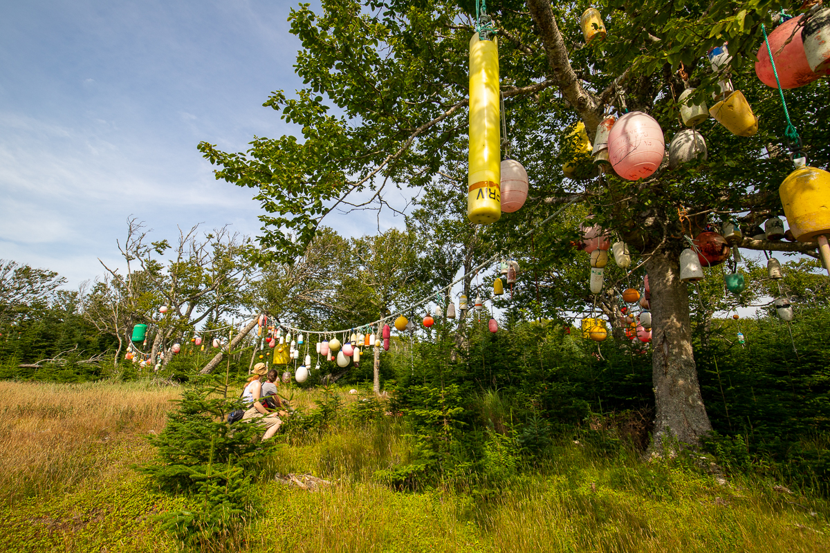
The trail continues to follow along the clifftops with several more spectacular viewpoints until it comes to a cabin with the most unique yard decorations. The trees are filled with colourful buoys. The ATV trail that accesses this cabin can be used as an access trail out to Deep Cove.
The trail then drops down into Bradford Cove passing by several camps. At Bradford Cove the trail passes through a field with beautiful views of the cove. Here there is another access trail that takes you out to Deep Cove.
Not far past Bradford Cove there is another access trail out to Deep Cove. The trail goes through some beautiful hardwood stands with more knarly birches. Soon you will come to a split in the trail. There is an upper trail to the left that bypasses Hay Point. The lower trail to the right loops down around to the Hay Point Access Trail. The Hay Point access trail is a bit steep but has ropes to help get down. Hay Point has, in our humble opinion, the most spectacular views on Grand Manan. The grassy point juts out into the bay and provides unfettered views of the coast to the north.
Past Hay Point the trail passes by Bradford Cove Pond bypassing more camps. A section of the trail near the pond is a big puddle so there is a side trail that skirts around the water. From here the trail follows along an old road along the clifftops passing by a site where there was a boat accident in 1963. The trail then passes by the Southern Cross Lookout. The trail passes by several other amazing lookouts before reaching the Southwest Head Lighthouse.

Map
Store

Directions
The two ends of this section of trail are near Dark Harbour and at the Southwest Head Lighthouse. To access the trail from Dark Harbour drive out Dark Harbour Road. At the top of the hill near Dark Harbour you will find a wide parking area on the left. Park in this parking area. The trail enters the woods at the end of this parking area.
To access the trail from Southwest Head Lighthouse drive south on route 776. The road ends at Southwest Head Lighthouse. The trail starts by following old roads along the cliff tops behind the lighthouse.
There are also several access trails on this section on the trail. The first one is from Miller Pond to Dwelley's Pond. To get to this access drive through Grand Harbour on Route 776 and turn right onto Millers Pond Road. Follow this road for 400 meters and it will turn into a gravel road. Continue on the gravel road keeping right at a junction near the lake. After passing several driveways on the lake the road will turn sharply to the left. After one more driveway on the lake you will come to an ATV trail that goes into the woods at an angle on the right. This ATV trail is the start of the access trail. Make sure you park somewhere where you won't block the road for camp owners. For more information on this trail go to Millers Pond to Dwelleys Pond Access Trail page.
The second access trail is between Seal Cove and Sloop Cove. In Seal Cove turn onto King Street and drive to the end of the street. Here you will find a gate for a Cooke Aquiculture compound. Just before the gate on the right is an ATV trail. This is the start of the access trail. There is enough space to park along the road. For more details on this access trail go to the Seal Cove to Sloop Cove Access Trail page.
The third access trail is between Deep Cove and Bradford Cove. After driving down through the deep valley at deep cove turn right onto the Bradford Cove Road. Just inside the start of the road there is a wide spot to park. Continue on this trail on foot from here. For more details on this access trail go to the Deep Cove to Bradford Cove Access Trail page.

Trail Last Hiked: October 8, 2022.
Page Last Updated: October 21, 2022.