Saint Croix Island National Historic Site Trail
Gallery
Store

Quick Facts
| Difficulty | accessible |
| Trail Type | loop |
| Distance | 240 metres |
| Estimated Time | 10 mins |
| Surface Type | crushed rock |
| Elevation Change | 12 meters |
| Features | historical site, river view |
| Trail Markers | none but easy to follow |
| Scenery Rating | beautiful |
| Maintenance Rating | well maintained |
| Cell Reception | strong |
| Dog Friendly | on a leash |
| Fees | no |
Description
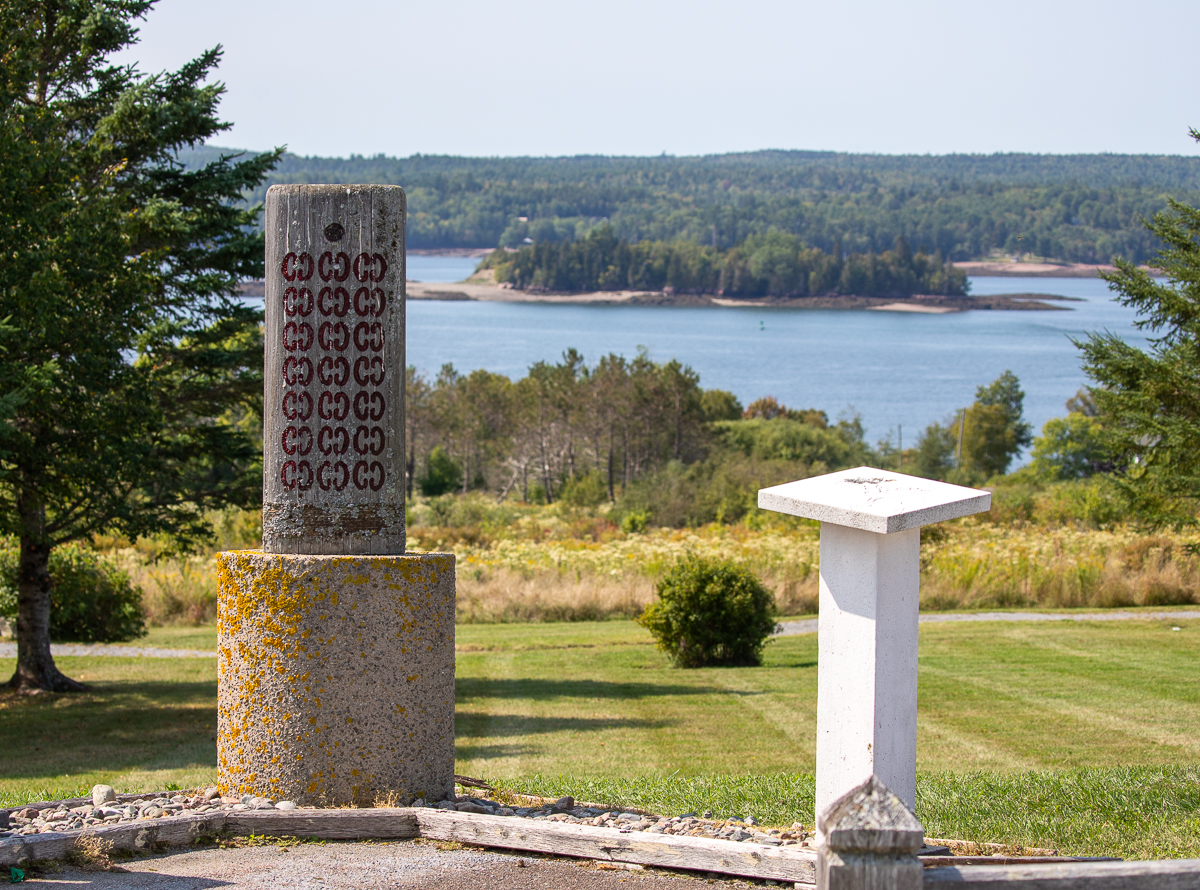
The trail at Saint Croix Island International Historic Site is short but packed full of history on the many interpretive signs (see below) along the trail. The trail looks down across a field to the Saint Croix River where you will see the historic island. It is a wide crushed rock trail that loops down through the field. There are two large shelters with picnic tables making this a great place to stop and have a picnic. The interpretive signs tell the stories of some of the first European visitors to the continent and their failed attempts to build a settlement on the island.
The United States border runs down the middle of the river and the island is actually on the United States side of the border. There is also a United States version of the historic site on the opposite shore. If you want to have the full experience then consider crossing the border at St. Stephen/Calais, and going to check it out. For more information go to the National Park Service page.

Map

Directions
From Route 1 take exit 25 to Saint Andrews at Bayside. From here drive for 8.8 kilometres and you will see the Saint Croix Island Historic site on your right.
If you are coming from Saint Andrews turn left (route 127) at the Tim Hortons when leaving town. You should be driving along the golf course and pass by the Huntsman Marine Science Centre. Drive for 7 kilometres and you will see the sign for the Saint Croix Island Historic site on the left.
From the Sign
The River Flows On...
Samuel de Champlain, explorer and geographer on Sieur de Monts' expedition, recorded in late June 1604 that:
"...we entered a river...wherein...we found two islands - one very small and near the western shore, and the other in the middle of the river."
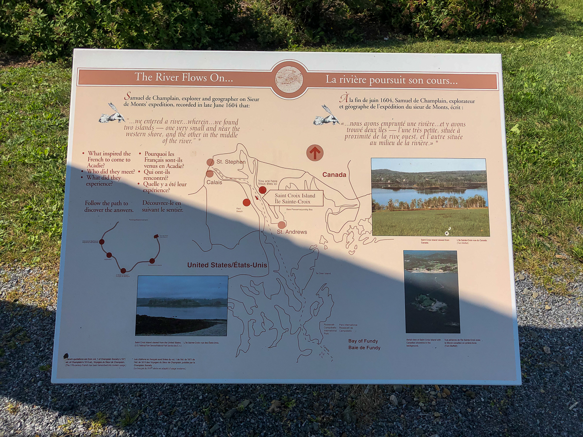
- What inspired the French to come to Acadie?
- Who did they meet?
- What did they eperience?
Follow the path to discover the answers.
From the Sign
Saint Croix Island International Historic Site
On Saint Croix Island in 1604, French nobleman-courtier Pierre Dugua Sieur de Monts established a settlement. This outpost was the first attempt by the French at year-round colonization in the territory they called La Cadie or L'Acadie.

The experience of the French on Saint Croix Island taught them much about adapting to the environment and interacting with the Aboriginal peoples. These insights formed the foundation for an enduring French presence in northeastern North America.
Enjoy your visit.
From the Sign
A French Colony in Acadie
"Having found no place more suitable than this island...Sieur de Monts...allowed me to draw up the plan of our settlement."
Seventy-nine men, including noblemen, artisans, labourers, Catholic and Protestant clerics, surgeons, and soldiers spent the winter of 1604-05 on Saint Croix Island. The French brought with them things they considered essential, such as weapons, grains, utensils, tools, trade goods, and a few prefabricated frame buildings.
From the Sign
Where Two Worlds Met
The Micmac, Maliseet and Passamaquoddy hunters and traders provided a commercial lifeline for Sieur de Monts' colony. Their first-hand knowledge of the territory allowed these entrepreneurs to control the supply of furs.
Through their earliest dealings with French traders, the Micmac, Maliseet, and Passamaquoddy were very familiar with the usefulness of European trade goods. To continue this exchange of furs for European items, they formed trade alliances with Sieur de Monts.

The anticipation of huge profits from the fur trade motivated people to participate in Sieur de Monts' expedition. In Europe, the popularity of beaver pelt hats made beaver pelts a highly valued commodity.
In 1603, Sieur de Monts received from Henry IV a ten-year exclusive right to the fur trade, and the title of Lieutenant-General of Acadie, a territory between the 40th and 46th parallels. In return, Sieur de Monts had to undertake and pay the costs of colonization. In this way, Henry IV was able to realize his vision of overseas colonization.
From the Sign
A Winter of Despair
"It was difficult to know the country without having wintered there. Winter came upon us sooner than we had expected..."
Could you survive the winter on Saint Croix Island if...
- dangerous ice cut you off from the mainland?
- there was over a metre of snow from October to April, with extremely cold winds?
- there was a severe shortage of firewood and fresh water? and
- your only rations were salted meat and vegetables?

"...of the seventy-nine of us, thirty-five died [of scurvy] and twenty others were near it...these circumstances made Sieur de Monts and others dissatisfied with the settlement...There are six months of winter in that land."
In 1968-69, archaeologists examined 23 burials on Saint Croix Island. The bodies were buried with the feet towards the east, as was Christian burial practice at the time. Variations in positions were due to changes in the location of the sun on the horizon during the winter and spring. Research conducted in 1995 suggests that the deceased men ranged in age from about 17 to 45 years.
From the Sign
Moving on
"In order to escape the cold and dreadful winter we experienced on Saint Croix Island, Sieur de Monts decided to move the settlement to another location. Having...found no port that was acceptable to us...we outfitted two pinnaces to transport the woodwork of the homes on Saint Croix Island to Port Royal...where we judged the climate to be much more agreeable and mild."
In the fall of 1605, Sieur de Monts returned to France. Sieur de Monts continued his involvement with Acadie but never returned.
From the Sign
Place to Settle
Sieur de Monts named the island Saint Croix Island, and Champlain recorded that:
"The island is covered with fir, birch, maple, and oak. It is naturally well located...and is easy to fortify...We considered this the best place we had seen on account of its location, fine surroundings, and the interaction we were expecting with the Aboriginal peoples of these coasts and the interior since we are in their midst...Around our settlement at low tide there are plenty of shellfish - such as clams, mussels, sea-urchins, and snails..."
From the Sign
A Checkered History
In 1984, the United States Congress designated Saint Croix Island an international historic site in recognition of the historical significance of the island to the United States and Canada.
The majestic Saint Croix River forms part of the Canadian Heritage Rivers System, and the currents of history continue to flow between both countries
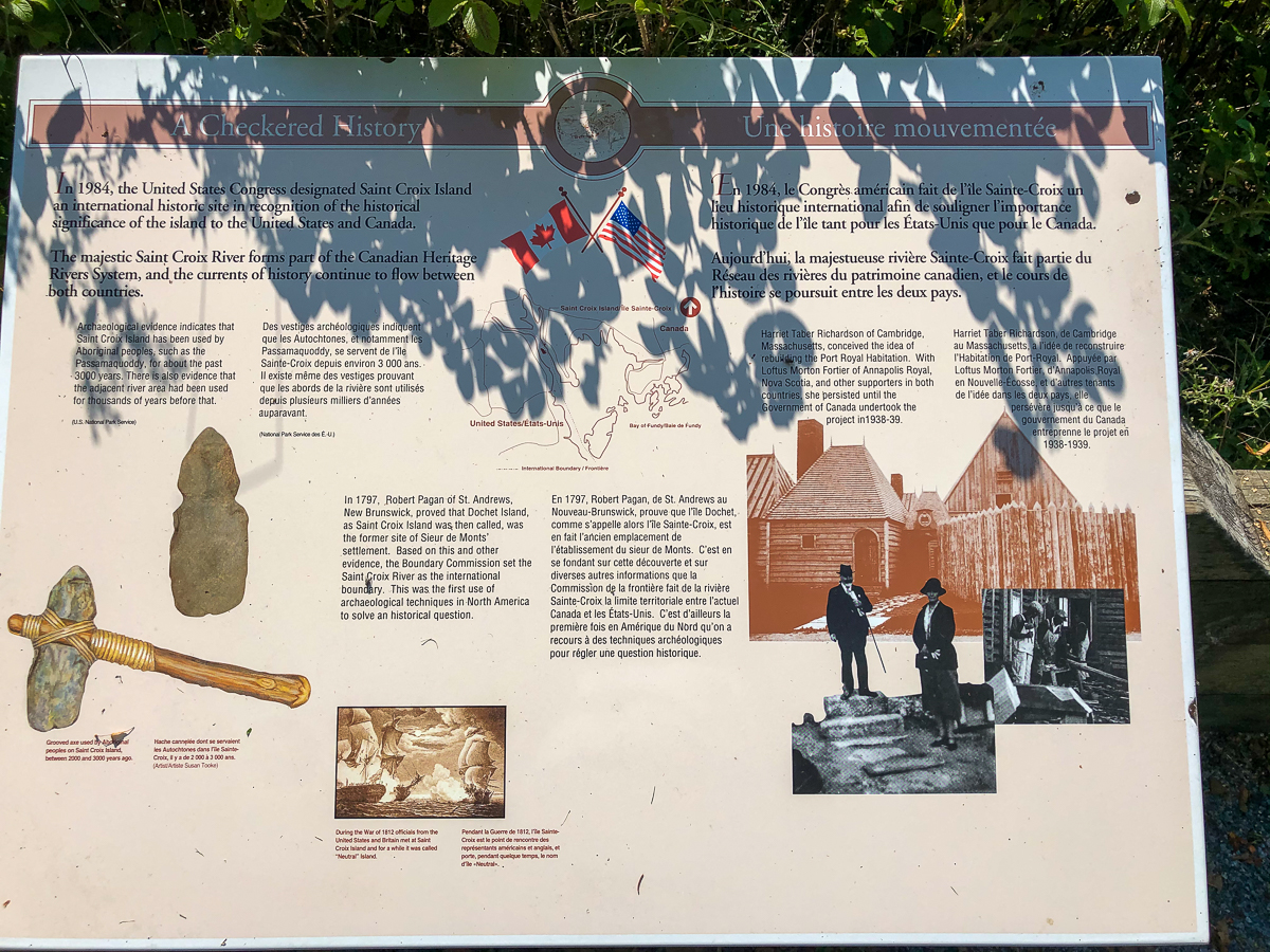
Archaeological evidence indicates that Saint Croix Island has been used by Aboriginal peoples, such as the Passamaquoddy, for about the past 3000 years. There is also evidence that the adjacent river area had been used for thousands of years before that.
In 1797, Robert Pagan of St. Andrews, New Brunswick, proved that Dochet Island, as Saint Croix Island was then called, was the former site of Sieur de Monts' settlement. Based on this and other evidence, the Boundary Commission set the Saint Croix River as the international boundary. This was the first use of archaeological techniques in North America to solve an historical question.
From the Sign
In Champlain's Footsteps
The precise mapping of Acadie in the 17th century was the work of one individual - Samuel de Champlain.
Between May 1604 and August 1605, travelling by barque, pinnace, canoe or on foot, Champlain surveyed and charted the present-day south shore of Nova Scotia, the Bay of Fundy, and southward to Cape Cod. He accurately recorded the harbours and natural features, named landmarks, and noted what we learned from the Micmac, Maliseet and Passamaquoddy, and Abenaki (whom he called the Souriquois, Etechemins, and Almouchiquois, respectively).

From August 1605 until his return to France in August 1607, Champlain continued to explore Acadie from his base at the Port Royal Habitation.
Champlain brought clarity to North American cartography. His maps replaced the vague and contradictory ones of earlier map-makers from France, Spain, England and Portugal. His accounts provided information that greatly assisted in the future colonization of North America.
From the Sign
The Story Continues...
We invite you to visit Saint Croix Island International Historic Site, operated by the United States National Park Service. It is located 13 km (8 miles) south of Calais, Maine, along U.S. 1. The Site includes a small parking area, viewing deck, and toilet. There is no ferry service to the island.
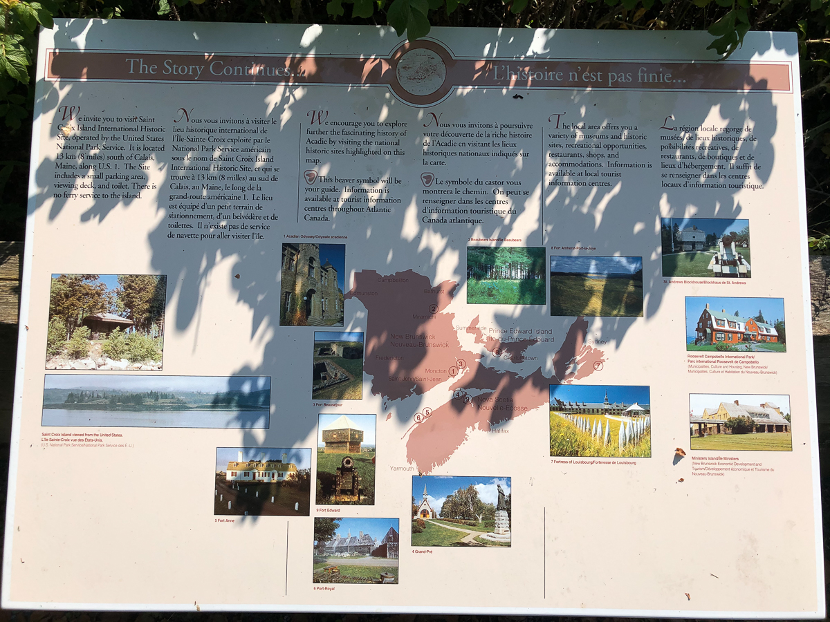
The local area offers you a variety of museums and historic sites, recreational opportunities, restaurants, shops, and accomodations. Information is available at local tourist information centres.
Other Trails in Saint Andrews
Trail Last Hiked: September 9, 2020.
Page Last Updated: October 31, 2021.