Dieppe Riverfront Trail
Gallery

Store
Quick Facts
| Difficulty | accessible |
| Trail Type | linear |
| Distance | 10.8 km one way |
| Estimated Time | 3 hr 30 mins |
| Surface Type | crushed rock |
| Elevation Change | 5 meters |
| Features | river, grasslands |
| Trail Markers | signs |
| Scenery Rating | beautiful |
| Maintenance Rating | well maintained |
| Cell Reception | strong |
| Dog Friendly | on a leash |
| Fees | none |
Description
The Riverfront Trail starts by traveling behind a few malls on Champlain Street. After that it turns away from the river and follows along an old dyke with a drainage ditch on one side. If you are visiting in the summer you will probably see many different types of ducks and muskrats in the ditch. The trail travels through a wide grassland that is interspersed with small streams and ponds. The amount of wildlife in these grasslands is the most I have seen in any one place in the province. Depending on the time of year you will see many different ducks, songbirds, raptors, pheasants and foxes.

Along the trail you will find lookout platforms, monuments, interpretive signs, benches, playgrounds, and even a lookout tower. The trail is also used by bikes and is part of the Trans Canada Trail.
Once past Chartersville Marsh the trail travels between the back of subdivisions and the grasslands. Near the end of the trail it once again comes close to the river before turning inland through a small patch of forest. The trail then crosses Fox Creek where you will find a lookout tower. From here the trail travels between fields and the river before once again turning inland to end on Dover Road.
Map

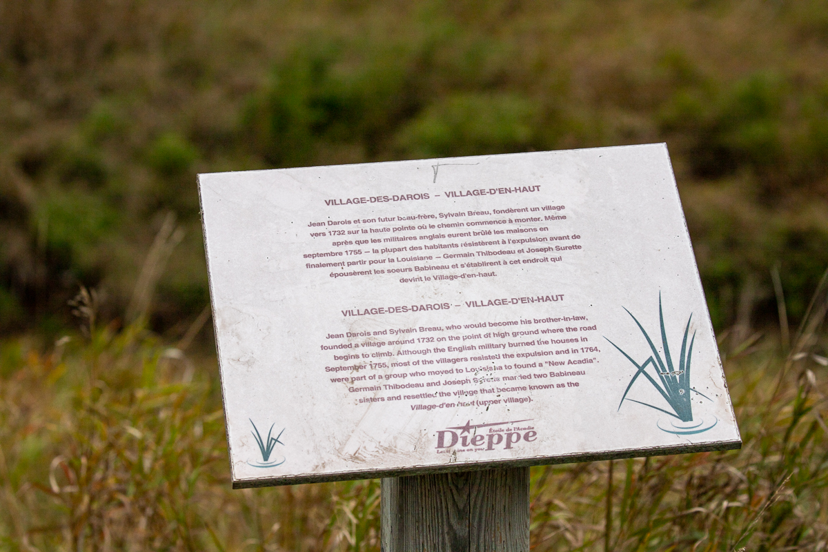
From the Sign
VILLAGE-DES-DAROIS - VILLAGE-D'EN-HAUT
Jean Darois and Sylvain Breau, who would become his brother-in-law, founded a village around 1732 on the point of high ground where the road begins to climb. Although the English military burned the houses in September 1755, most of the villagers resisted the expulsion and in 1764, were part of a group who moved to Louisiana to found a "New Acadia". Germain Thibodeau and Joseph Surette married two Babineau sisters and resettled the village that became known as the Village-d'en-haut (upper village).
Directions
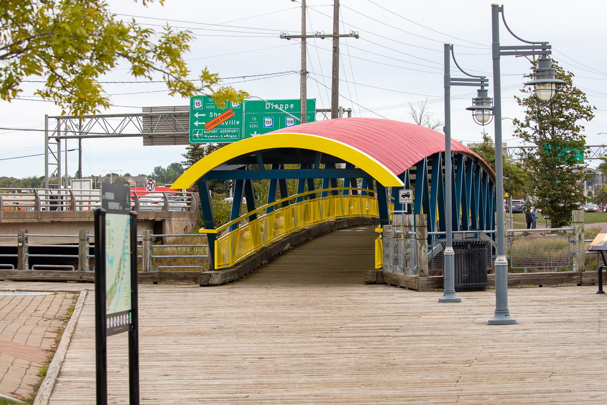
There are four main access point to this trail. The first is from the parking lot behind the Chateau Moncton Hotel. Turn right to follow the Moncton section of the trail and turn left, and cross the walking bridge with the red roof, to follow the Dieppe section of the trail. The second access trail is off Virginia Street behind Swiss Chalet.
The third access point is from a small parking lot off Acadie Road, on the far side of Chartersville Marsh. The fourth main access point is a paved parking lot along Amirault Street, just off the end of Melanson Street. An access trail runs along the right side of the parking lot.
Between Chartersville Marsh, and the trail end on Dover Road, there are many other access points from subdivisions.
From the Sign
Journey to a New Country
This journey began in Europe where eight families, seven of German origin, and one of Welsh origin, set out to seek a new homeland. It ended here, on these muddy banks of the Petitcodiac River, when the families of John Copple (Koppel), Michael Lutz, Jacob Ricker, Matthias Sommer, Heinrich Stieff, Jacob Treitz, Gorge Wortman(n) and Charles Jones, set foot on this Land.

Between 1749 and 1754, these families embarked on an ocean voyage bound for Philadelphia, Pennsylvania, taking with them meager belongings such as articles of clothing and small personal effects, including the Bible. Many of these settlers would work off their ocean passage on farms and for local merchants. While this might take ten years or more, their goal was to acquire their own land someday.
By the Treaty of Paris in 1763, France had surrendered most of its North American possessions to the British Crown, which, in turn, had granted four companies, including one owned by American statesman, Benjamin Franklin, the rights to settle 100,000 acres of river front land of Monckton Township. The town had instructed the companies to seek out "Frugal, labourious and industrious people who will not only improve and enrich their property but, if need be, pertinaciously defend it." Having signed the Articles of Agreement binding them to the landholding companies for a period of five years, these settlers or "Pennsylvanien Deutsche" boarded a single-masted sloop on April 20, 1766, to begin the final leg of their journey.
From the Sign
A Rich Biodiversity
Teeming with life, the Petitcodiac River watershed is located in the Kings, Westmorland, and Albert counties in south-east New Brunwick, covering an area of about 2,071 km2. A wide variety of marine and freshwater species of fish, molluscs, mammals, reptiles, insects, birds, plants, and trees thrive in its waters and along its banks, throughout its wetlands, and within its surrounding forests.
Twice a day, 115 billion tonnes of water flows in and out of the Bay of Fundy. The high concentration of sediments, the mix of fresh and saltwater, and vast areas of mudflats uncovered at low tide provide a vital source of nourishment for many migratory birds.
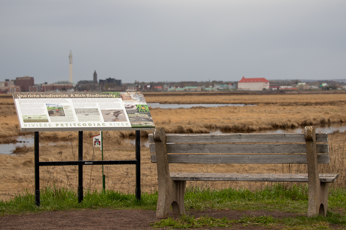
The province's ongoing Petitcodiac River Restoration project is countering the ecological damage incurred in the decades following the construction of the causeway in the late 60s. The first five years of monitoring data collected by the Petitcodiac Fish Recovery Coalition indicates that the overall health of the river's ecosystem is improving.
The Petitcodiac and its tributaries are home to a large number of fish, including rainbow smelt, brook trout, blueback herring, sturgeon, striped bass and shad. Marine mammals, such as pilot whales, harbour porpoises, harbour seals and porbeagle sharks occasionally frequent the river.
Every year, from late July to early August, up to 2 million migrating shorebirds converge on the mudflats of the Bay of Fundy and along the banks of the Petitcodiac. They snack on Corophium volutator, a mud shrimp only 5 mm long that feeds on algae and detritus, burrowing in the mudflats at low tide.
From the Sign
A skulk of foxes
The red fox has a reputation for its cunning and intelligence, but a closer look reveals that this animal is a quick learner that behaves, for the most part, extremely cautiously.
Most commonly rusty-red in colour, the red fox may also be greyish brown or black and silver, but its bushy tail is always white-tipped. Able to hear low frequency sounds, the red fox hunts with a distinctive style. It listens for the rustling sounds of a small animal moving in deep grass, then leaps upward - straight-legged - and pounces down hard on its quarry. A frantic dig may ensue if sounds are detected under-ground or in snow.
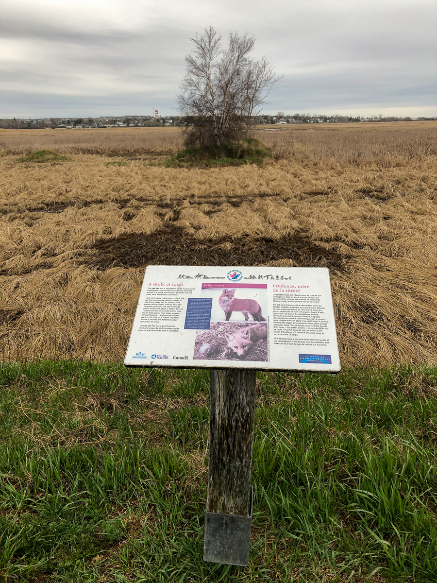
Though the fox has a penchant for mice and voles, its diet includes plants, insects, and whatever else is available.

From the Sign
Good morning!
Inquisitive, enchanting, and mischievous are a few words to describe a Blue Jay, but noisy is perhaps the best. Vocalizations range from raucous jay, jay, jay wake-up calls, to soft, musical chatter. This master of mimicry is particularly good at imitating hawks. The ploy could be to scare other birds away from their nests, eggs, and feeding sites - free food for the taking - or it could be to keep intruders away, if the jay is threatened.
A Blue Jay often harasses other birds - including its most dangerous enemies: hawks and owls. It can end up as prey if it's not careful, and its feathers , left behind after an attack, may eventually be found lining the nests of the very birds this jay likes to bother.

A Blue Jay's haphazard storage of its winter supply of nuts and acorns contributes to the reforestation of some areas - especially stands of oak.
Trail Last Hiked: May 5, 2021.
Page Last Updated: December 11, 2021.