Valley Trail
Gallery
Store

Quick Facts
| Difficulty | accessible |
| Trail Type | linear |
| Distance | 1.1 km mapped |
| Estimated Time | 45 mins return |
| Surface Type | crushed rock |
| Elevation Change | 8 meters |
| Features | river, park |
| Trail Markers | none but easy to follow |
| Scenery Rating | beautiful |
| Maintenance Rating | well maintained |
| Cell Reception | strong |
| Dog Friendly | yes |
| Fees | none |
Directions
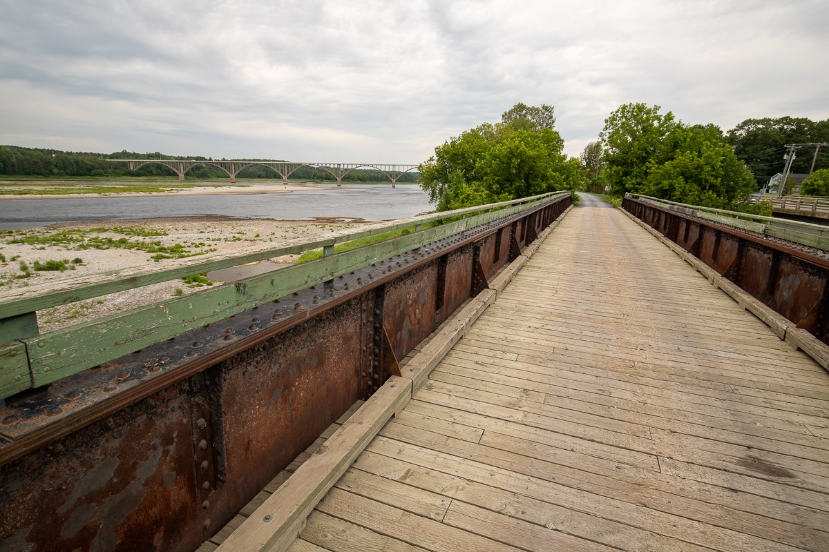
The Valley Trail is an old rail bed that travels through the St. John River valley. It can be accessed from many locations. If you are in Hartland the best way to access it is to come off the covered bridge in downtown Hartland and turn left onto Main Street. After going through town you will see the trail start to follow the road on the right. Continue for 500 metres from the covered bridge, and just before you cross a bridge over Becaguimac Stream, turn right into a small gravel road. This leads to a small parking area for the Becaguimac Stream Nature Trails. Go back out to the road and you will see where the Valley Trail crosses the road. Turn left on the trail to head back into town or turn right on the trail to cross an old train bridge and continue up through the valley. On the other side of the train bridge is a small park with shelters, picnic tables, and interpretive signs.
Another way to access the trail is to park at the parking lots on either side of the covered bridge in town. From here you can walk down towards the river and find the Riverfront Trail that goes under the covered bridge and follows along the river. Turn right on this trail and follow it to the end at Maple Street. Follow Maple Street away from the river for a block and you will find the Valley Trail crossing in either direction. Turn right to go through town or turn left to walk out to the Becaguimac Stream Nature Trails and Charles R. Allen park.
Map

Description
The Valley Trail is part of a larger trail system that travels through the province on old rail beds. This section of the trail follows along the river valley so you can take a long walk or a short walk. The trail is a wide, crushed rock trail so very accessible. The trail provides amazing views of the St. John River.
Features along the trail near Hartland include the Charles R. Allen Park near the train bridge crossing Becaguimac Stream. On the other side of the bridge and across the road is the parking lot that accesses the Becaguimac Stream Nature Trails. The trai continues through the centre of town. If you want to continue along the waterfront and not go through town then turn right on Maple Street and follow it to its end at Main Street. Cross Main Street and you will find the start of the grassy Riverfront Trail.

Once the trail goes through town it crosses back over the road and continues to travel along the river through to the Town of Woodstock.
From the Sign
The 'sea eagle'
The Bald Eagle is Canada's largest bird of prey. Usually found near water, it feeds mostly on fish and carrion.
Adult bald eagles often mate for life, renewing their bonds in the spring with a spectacle of aerobatics. A huge nest is built or added to each year, usually in the largest tree available. It takes 14 to 18 weeks from the time the eggs (one to three) are laid to when the eaglets first fly.

A young bird (often mistaken for a Golden Eagle) is dark brown overall with blotchy white markings on the underside of its wings and tail. Adult colouring - a white head and tail, and yellow beak - develops when the bird reaches four to five years of age.
The Bald Eagle is one of only two species called eagles (the other is the Golden Eagle) in Canada. This raptor averages 85 cm in height, 5 kg in weight, and has a wingspan of over 2 m. An important symbol in Native culture, the Bald Eagle is depicted in stories, artwork, apparel, dance, and spiritual ritual.
From the Sign
The Arthur Kyle Nature Preserve
About the Preserve...
The Arthur Kyle Nature Preserve, otherwise known as Middle Becaguimac Island, is the 7-acre gravel formation you see in front of you. Hartland native Dr. Joseph Kyle donated this land to the Nature Trust of New Brunswick in 2004 to protect and preserve the island for the benefit of nature and future generations of New Brunswickers.
Becaquimec Protects
This preserve will see formal protection bestowed on a healthy population of the threatened Anticosti aster (Symphyotrichum anticostense). This preserve is the first of its kind for the Anticosti aster in New Brunswick, and possibly its entire range. The species is typically found in the Gulf of St. Lawrence. There are at least four populations of the Anticosti aster on this Island.

About the Anticosti Aster
The Anticosti aster is a slender perennial plant that grows 50cm to 60cm tall. Its small daisy-like flowers bloom in late summer, have a yellow centre and pale purple or blue outer rays, and occur on very long stalks. The leaves are very narrow and often arching.
Anticosti aster is dependent on cyclic disturbances caused by spring high waters to keep shrubs and other competing species from taking over the habitat and gradually eliminating the aster.
Other Species
Species found on Becaguimac Island include Brunet's milk-vetch, Stemless locoweed, Blue flag iris and giant Jerusalem artichokes.
The Nature Trust is a province-wide, non-government, charitable land trust. We work with private landowners to conserve our province's outstanding natural landscapes. Support Conservation. Become a Member of the Nature Trust of New Brunswick. Call 506 457-2398 or email [email protected]. Visit our website: www.naturetrust.nb.ca
From the Sign
Distant drummer
The explosive burst with which the Ruffed Grouse takes flight can be startling, though the bird may vanish as swiftly as it appeared, flying skillfully through thick underbrush.
Low-pitched drumming reveals the presence of a male, proclaiming his territory. Standing on a fallen log, tail fanned and neck ruffed, he beats his wings rapidly, creating reverberating sound that can be heard and even felt for quite a distance. Most frequently heard in springtime, he advertises his location to females ready to mate.
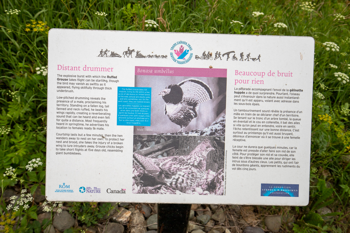
Courtship lasts but a few minutes, then the hen wanders away to nest on her own. To protect her nest and brood, she fakes the injury of a broken wing to lure intruders away. Grouse chicks begin to take short flights at five days old, resembling giant bumblebees.
The Ruffed Grouse does not migrate, living its life within a few acres of deciduous or mixed forest. In the east, grouse are mostly grey and only sometimes red. On the west coast, they are reddish brown.
From the Sign
The 'fishing eagle'
The Osprey is a large, powerful raptor, particularly well adapted for fishing. Its feat are large, but unlike other raptors, the Osprey's versatile outer toe can be pointed forward or swung backward, like a second hind toe. This arrangement, combined with the spiny scales on its toes, makes grasping slippery fish easy.
Upon spying a fish near the surface of the water, this huge, yet wonderfully light bird plunges in a bent-wing dive, hits the water with a great splash - feet first - and dissappears. Moments later it rises with its quarry, shakes like a cat or dog, and takes off to its perch or nest to feed.

The Osprey is one of the most widely distributed of all birds. Their nests, added to year after year, may reach the size of a single-car garage.
From the Sign
Town of Hartland
- Settled 1802 by William Orser United Empire Loyalist near where the Becaguimac Stream flows into the St. John River.
- Originally known as Mouth of the Becaguimac
- Becaguimac - Abekaquimek - Maliseet for salmon bed
- Incorporated October 2, 1918
- Smallest incorporated town in Canada
- Fires in 1907 and 1980 destroyed many businesses on Main Street
- Home of the longest covered bridge in the world

Other Trails in Hartland
Trail Last Hiked: July 19, 2020.
Page Last Updated: October 23, 2021.