Maliseet Trail
Gallery

Store

Quick Facts
| Difficulty | moderate |
| Trail Type | linear |
| Distance | 1.5 km one way |
| Estimated Time | 1 hr 30 mins |
| Surface Type | forested, some wood chips |
| Elevation Change | 87 meters |
| Features | waterfall |
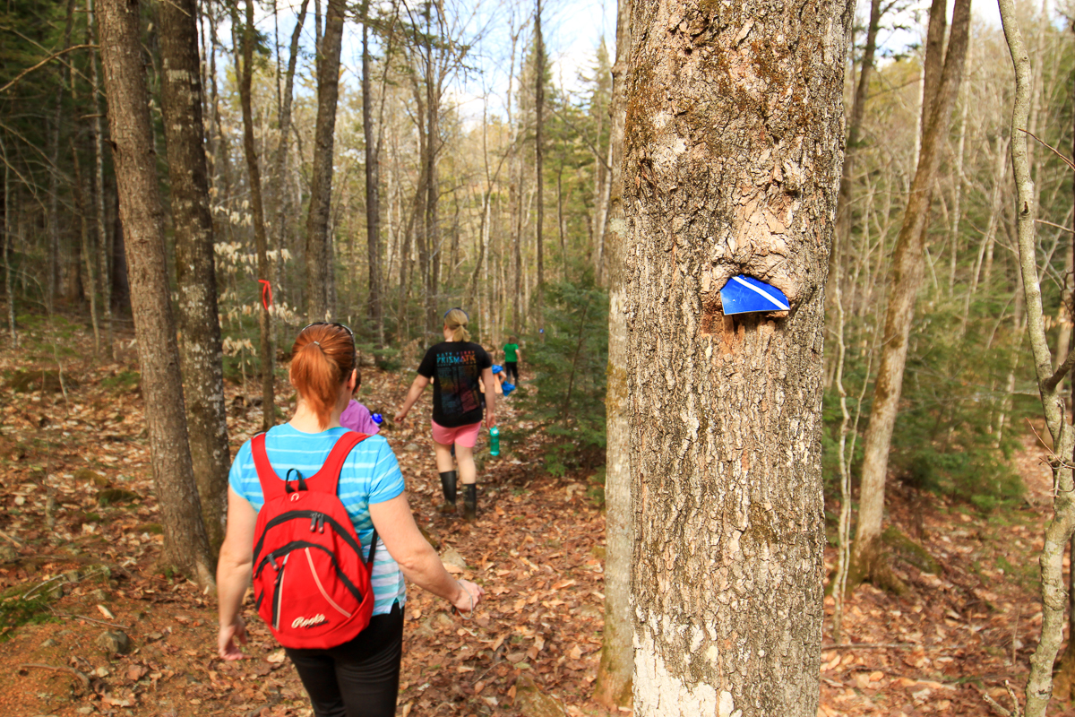
| Trail Markers | blue squares, bear paw signs |
| Scenery Rating | must see |
| Maintenance Rating | well maintained |
| Cell Reception | medium |
| Dog Friendly | yes |
| Fees | none |

Map
Videos
Podcasts
From the Sign
Fort Meductic
Fort Meductic was a Maliseet settlement until the mid 18th century. It was located directly adjacent to the Maliseet Trail on the Saint John River. The fortified village of Meductic was the principal settlement of the Maliseet First Nation from before the 17th century until the middle of the 18th century.

Directions
From Fredericton (top of the hill on Regent Street) head west on Highway 2 towards Edmundston. Drive for 67 kilometres, take exit 212 to Meductic and turn right on highway 165. At the bottom of the hill go left and continue on highway 165. After another 7 kilometres look for a long paved parking area on the left and you should see the signs for the trail.
From Woodstock (Connell Street - Route 550) take exit onto highway 2 heading east towards Fredericton. Drive 15 kilometres and take exit 200 and turn left onto Dugan Road. When you get to the bottom of the hill turn right onto Highway 165. Drive for another 2 kilometres and look for a long narrow parking area on the right. You should also see the signs for the trail.

Description
From the parking area the trail ascends through a mainly softwood forest and transitions into a hardwood ridge. There is a picnic table in a cedar stand about half way up the hill. At the top of the hill (about a kilometre) the trail comes to a junction. Going straight will take you out to the highway in a couple hundred metres. You will want to go to the right.
The right branch of the trail descends towards the falls. After a short distance the trail branches again. The trail to the right continues to descend to the bottom of the falls. The trail to the left ascends to the top of the falls. There is a picnic table at the top of the falls and a fence across the top for safety. This is one of the tallest waterfalls in the province at around 80 feet.
The main trail goes down to the bottom of the falls. At the bottom of the hill you will come to the stream below the falls. You will come around a rocky outcrop on the left and be looking up at the falls. The stream is shallow so make sure you check the falls out from all angles. Be careful though because the rocks are always wet and can be slippery.
Map
Trail History
The Maliseet trail was an ancient travel route (portage) for the Maliseet First Nations. The trail joined the Saint John River with the Penobscot river in Maine and was used up until the 1600s. The trail connected through many lakes, rivers and streams and was comprised of over 200 km of paddling and less than 20 km of portaging. Today the Maliseet hiking trail is only a small portion of its former self and is mainly used to access Hays Falls. A rough map of the full Portage Trail is provided below.

From the Sign
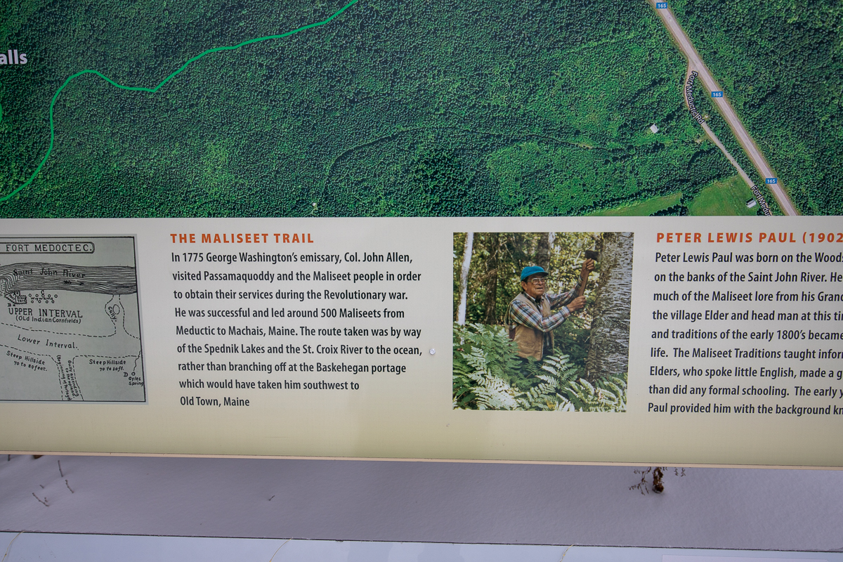
The Maliseet Trail
In 1775 George Washington's emissary, Col. John Allen, visited Passamaquoddy and the Maliseet people in order to obtain their services during the Revolutionary war. He was successful and led around 500 Maliseets from Meductic to Machias, Maine. The route taken was by way of the Spednik Lakes and St. Croix River to the ocean, rather than branching off at the Baskehegan portage which would have taken him southwest to Old Town, Maine.
From the Sign
Peter Lewis Paul (1902-1989)
Peter Lewis Paul was born on the Woodstock First Nation, on the banks of the Saint John River. He grew up absorbing much of the Maliseet lore from his Grandfather who was the village Elder and head man at this time. The stories and traditions of the early 1800's became part of his daily life. The Maliseet Traditions taught informally by the Elders, who spoke little English, made a greater impression than did any formal schooling. The early years of Peter Paul provided him with the background knowledge of a decaying culture. He was a Maliseet Ethnohistorian who, from the 1930's on helped and advised many of his contemporaries in exploring Maliseet culture. Peter Lewis Paul became a fountain of traditional knowledge and generously shared information with numerous professionals. He was the recipient of many honors, he was awarded a Centennial Medal in 1969, received an honorary Doctor of Letters degree from the University of New Brunswick in 1970 and the Order of Canada in 1987.


Trail Last Hiked: January 1, 2020.
Page Last Updated: January 19, 2020.