Howland Falls Trail
Map
Quick Facts
| Difficulty | easy |
| Trail Type | linear |
| Distance | 100 metres |
| Estimated Time | 15 minutes |
| Surface Type | rocky |
| Elevation Change | 24 metres |
| Features | waterfall |
| Trail Markers | none but easy to follow |
| Scenery Rating | beautiful |
| Maintenance Rating | well maintained |
| Cell Reception | medium |
| Dog Friendly | yes |
| Fees | none |
Podcast
Episode 12: Beat the Heat with Top 10 Swimming Waterfalls in New Brunswick
Directions
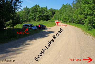
From the main gate at Mactaquac Provincial Park continue west of Route 105 for 18.8 km. Just past the Bear Island Community Center on your left you will find the Scotch Lake Road on your right.
The Scotch Lake Road is a gravel road and climbs the hill away from the river. After 900 meters you will come to a stone bridge. The waterfall is just below this bridge on the right. There is a parking area on the left just before the bridge. The trail down to the falls is just before that on the right. The trail starts at the back of a small turnout. You should be able to hear the falls from here. There is nothing to identify the trail but once you find it it is clearly identifiable.


Video
Store
External Links
Other Trails nearby
Trail Last Hiked: June 29, 2014.
Page Last Updated: August 17, 2014.