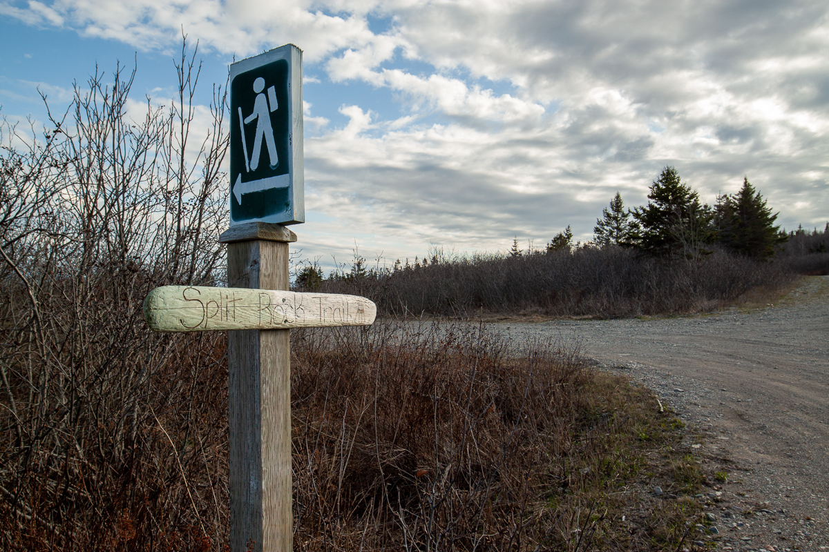
Split Rock Trail
Video
Quick Facts
| Difficulty | moderate |
| Trail Type | linear |
| Distance | 4.1 km |
| Estimated Time | 3 hrs return |
| Surface Type | forested |
| Elevation Change | 73 meters |
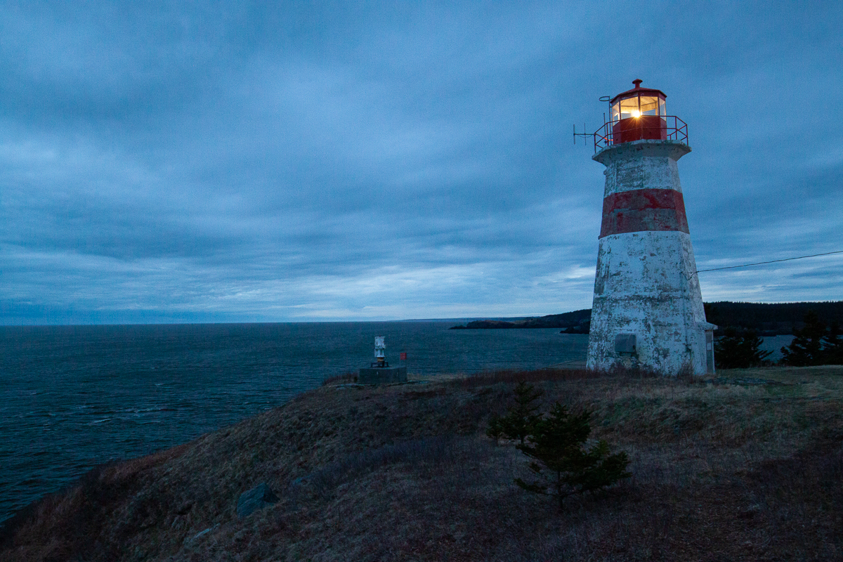
| Features | coastal views, lighthouse |
| Trail Markers | blue circles |
| Scenery Rating | beautiful |
| Maintenance Rating | well maintained |
| Cell Reception | strong |
| Dog Friendly | yes |
| Fees | donations accepted |
Gallery
Store

Map

Description
The trail is quite exposed in places and comes close to the cliff edge so use caution.
The Split Rock Trail is a coastal trail that reminds me of the Lighthouse Trail on Grand Manan Island but is much easier to access. The trail is only a 20 minute drive from Uptown Saint John.
The trail starts by going through a stretch of alders and then along an old road. Right away you will get views of the shoreline below. Soon the trail comes out into a grassy area with an old lookout platform overlooking the Coleson Cove power station and the surrounding shoreline. Just past this a small spur trail goes to the left and climbs a rocky outcrop for a more exposed view.
Continue on the trail and you will start to get views of the rocky shoreline cliffs to the west. There are several side trails on the left that take you to lookouts. Soon you will come to a steep descent where there are ropes to help you get down the hill. When you get to the bottom of the hill you will find a small, grassy meadow. On the other side of the meadow you will see a sign pointing to Split Rock out in the bay. Originally (and in the video below) I thought the side trail took you to Split Rock. Later I found out that Split Rock is actually the long rocky outcrop out in the bay. At high tide the tips of the outcrop are split. At lowtide you can see the two gray tips of the rock separated by a seaweed covered black base.

Split Rock is on a point and after this the trail turns north to go around an inner bay. If it's clear you may be able to see the Musquash Head Lighthouse across the small bay. The trail goes around the inner bay and passes a few rocky outcrops and many more rocky, coastal views. The trail passes a large crack in the earth. Someone has tied a rope onto an adjacent tree to help people climb down into this crack. I didn't have time when I was there and it was still icy. If you choose to climb down in the crack be careful.
As you get close to the lighthouse you will see views of it through the trees. Eventually you will come out into the field that surrounds the Lighthouse.
At this point you have two options, return the way you came or walk back on the road. The return on the road is about 1.5 kilometres shorter and easier. If you have time you can also continue on Troy's Trail and the rest of the Lorneville Trails. Black Beach can be reached by vehicle so if you have two vehicles you could leave one at each end of the two trails.
From the Sign
Musquash Estuary Marine Protected Area
Musquash Estuary
An estuary is a partially-enclosed coastal body of water where freshwater from a river flows into the ocean. The Musquash Estuary is located 20 km southwest of Saint John, New Brunswick. It is an important link to the marine life of the Bay of Fundy, including its commercial fisheries. Its large size and natural condition support diverse habitat and abundant wildlife, making it unique among Bay of Fundy estuaries.
Musquash Estuary Marine Protected Area
Marine protected areas are coastal or oceanic areas given special status to conserve and protect their habitat and wildlife. They are administered by Fisheries and Oceans Canada (DFO). On December 14, 2006, the Musquash Estuary was designated a marine protected area under Canada's Oceans Act. Designation is the result of a cooperative initiative between community and government. The boundary of the marine protected area is defined by the water level at low tide. Certain land between the water levels at low and high tide, known as the intertidal area, is also administered by Fisheries and Oceans Canada and is protected under the Fisheries Act.
Enjoy the Marine Protected Area Safely
You can have fun within the marine protected area but remember that weather, wind, waves, and tides can rapidly change. Shorelines can be slippery, old marine vessels and structures may be unsteady, and shoals, debris, and fishing equipment may be hidden at high tide. Please respect activities and property of others.
Directions
From Saint John drive west on Route 1. After leaving the city take exit 112 towards Lorneville. Turn left towards Lorneville and drive for 8 kilometres to the Coleson Cove power station. As the road turns left to enter the power station keep straight on a road that climbs the hill above the power station. Just past the power station you will find a large parking area on the left. This is the start of the trail.
Continue on this road for another two kilometres and you will descend to a parking lot at Black Beach. Troy's Trail enters the woods on the left and will take you to the lighthouse and to access to the other end of Split Rock Trail.
Other Trails in the area
Trail Last Hiked: April 29, 2018.
Page Last Updated: April 27, 2019.