Swallowtail Lighthouse Trails
Gallery
Store

Quick Facts
| Difficulty | easy |
| Trail Type | mixed |
| Distance | 700 meters |
| Estimated Time | 30 mins return |
| Surface Type | crushed rock |
| Elevation Change | 28 meters |
| Features | lighthouse, lookouts |
| Trail Markers | none but easy to follow |
| Scenery Rating | must see |
| Maintenance Rating | well maintained |
| Cell Reception | strong |
| Dog Friendly | on a leash |
| Fees | by donation |
Description
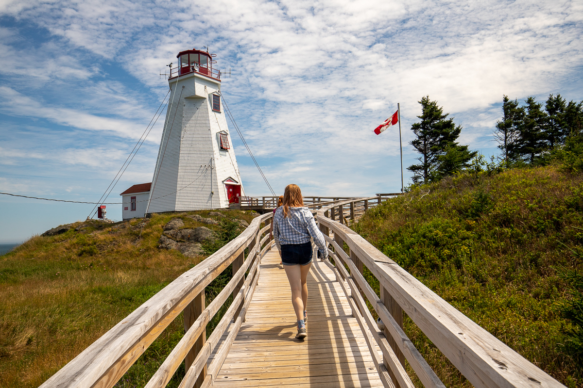
The Swallowtail Lighthouse is said to be one of the most photographed lighthouses in Canada (although I don't know how someone would measure that). It is definitely the lighthouse that I have photographed most. As you approach and leave Grand Manan on the ferry you go around the point for the lighthouse. It is also easily accessible from the ferry terminal and a must see if you are visiting the island.
You start by climbing down a long set of narrow stairs and crossing a bridge high over a deep, rocky ravine. It makes you feel like you are crossing a mote to get to a castle. The wide crushed rock trail the goes through a small patch of trees before emerging on a hill overlooking the lighthouse keepers house and the lighthouse beyond. When you get to the innkeepers quarters you can either take the boardwalk across to the lighthouse or climb the hill on the right to the helicopter pad. This is the highest point on the "island" so provides some of the most amazing views. Between the lighthouse and the helicopter pad there are several smal trails that lead around the hilly, grassy point.

If you have time we suggest sitting on one of the benches and looking for whales and seals out in the bay. Our favourite is the bench just behind the lighthouse.
Map

Directions
From the ferry terminal at North Head turn right onto Pettes Cove Road. After 160 meters turn left onto the Old Airport Road. Near the top of the hill (290 meters from Pettes Cove Road intersection) turn right onto Lighthouse Road. At the end of this short road (400 meters) you will come to the Lighthouse gift shop and a couple of small parking lots. Find a place to park and do down the hill beside the gift shop. You will see the lighthouse the and long stairs that descend to the access trails.

From the Sign
War of 1812
The United States invaded Canada because of the practice of impressment of American merchant sailors into the Royal Navy, trade restrictions, British support of native tribes blocking American westward expansion, and the possibility of annexing Canada. Settlers on Grand Manan Island saw much hardship, as privateers from both sides occasionally raided villages. Much of coastal Maine near Grand Manan was occupied by British military forces during and after the war, with Eastport not freed until 1818, after the signing of the Treaty of Ghent, beginning a long period of peaceful relations. The Americans met with more resistance than expected, and although impressment did end with this war, Canada continued to exist.

Although recognized as the key to protecting the Bay of Fundy (both New Brunswick and Nova Scotia), it wasn't until after the War of 1812 that the real value of Grand Manan Island was appreciated by the British from a military and naval point of view against American privateers.
A fort was proposed for Net Point in 1819, with safe harbour in Pettes Cove except on east winds. The plans included barracks, provision store, battery with six cannons, and a hospital, but fortunately it was never built. That is was not, finally, considered necessary to build the fort can be attributed in part to the lasting, peaceful resolution of the war.
From the Sign
Fog Bell History
A gun powder driven foghorn was originally installed in 1860 but was converted to a fog bell in or about 1915. This Meneely bronze bell was made in 1904 in West Troy, NY, and has been moved four times since it arrived. Weighing 900 kg (2000 lbs.) this was no easy feat. From 1915 to 1922 the bronze fog bell was located at the end of the peninsula. A mechanism that required winding regularly rang the bell when necessary. The bell was also rung when the ferry neared the island.
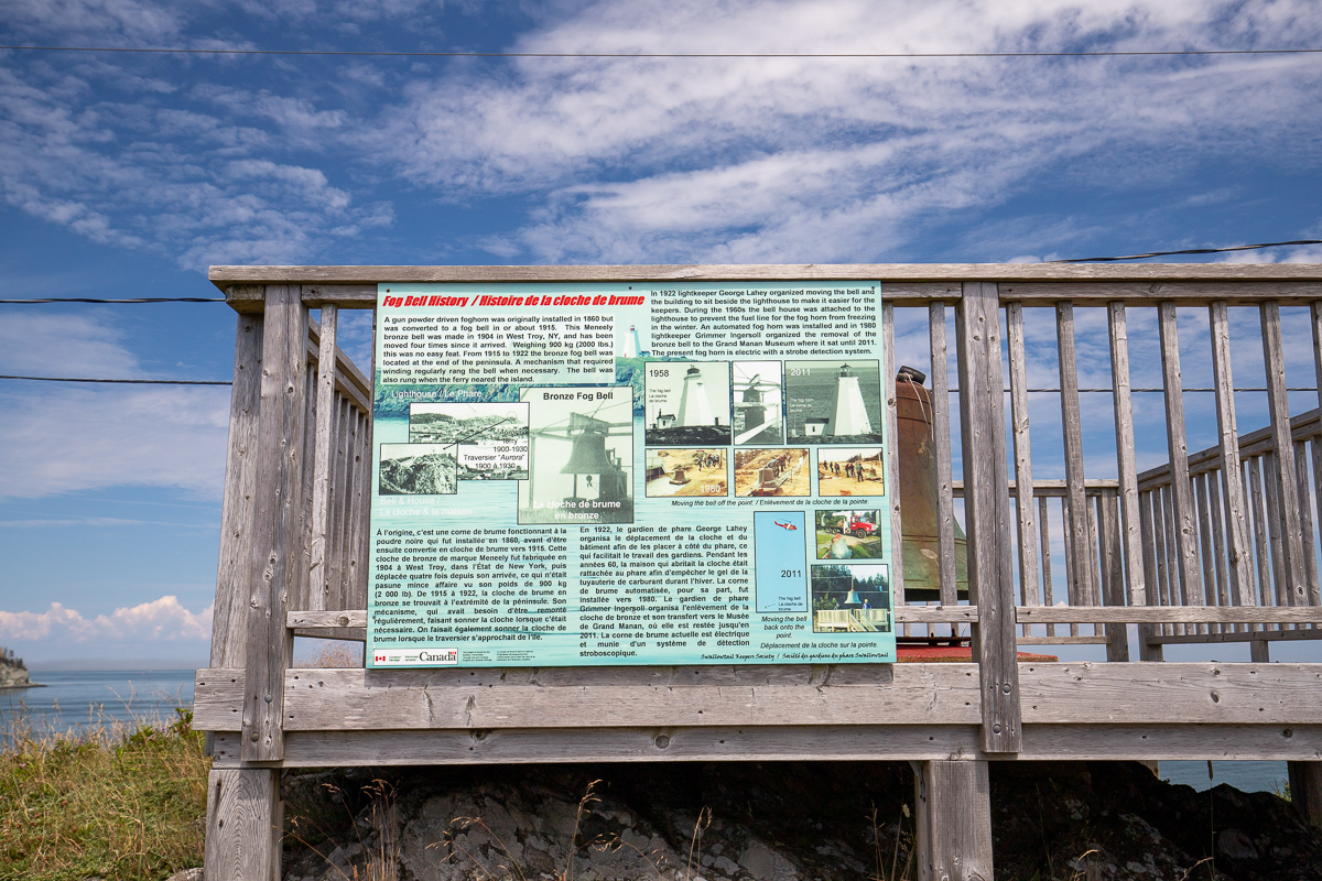
In 1922 lightkeeper George Lahey organized moving the bell and the building to sit beside the lighthouse to make it easier for the keepers. During the 1960s the bell house was attached to the lighthouse to prevent the fuel line for the fog horn from freezing in the winter. An automated fog horn was installed and in 1980 lightkeeper Grimmer Ingersoll organized the removal of the bronze bell to the Grand Manan Museum where it sat until 2011. The present fog horn is electric with a strobe detection system.
From the Sign
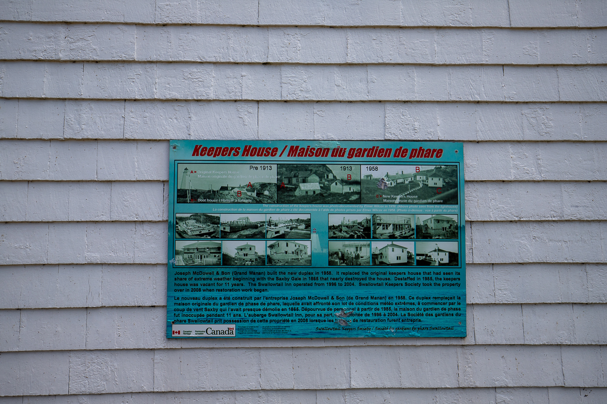
Keepers House
Joseph McDowell & Son (Grand Manan) built the new duplex in 1958. It replaced the original keepers house that had seen its share of extreme weather beginning with the Saxby Gale in 1865 that nearly destroyed the house. Destaffed in 1985, the keepers house was vacant for 11 years. The Swallowtail Inn operated from 1996 to 2004. Swallowtail Keepers Society took the property over in 2008 when restoration work began.
From the Sign
Swallow Tail Geology
The Swallow Tail peninsula is metamorphosed basalt, grey in colour, and about 550 Ma. Small veins of crystalline galena and quartz can be found. A large intrusion of lava (dyke), possibly dating from the Middle Triassic age (220 Ma), occurs along the stairs and under the foot bridge. The dyke is about 30 metres wide, and differs from the surrounding rock by its reddish colour and the angular shape to the rocks.

From the Sign
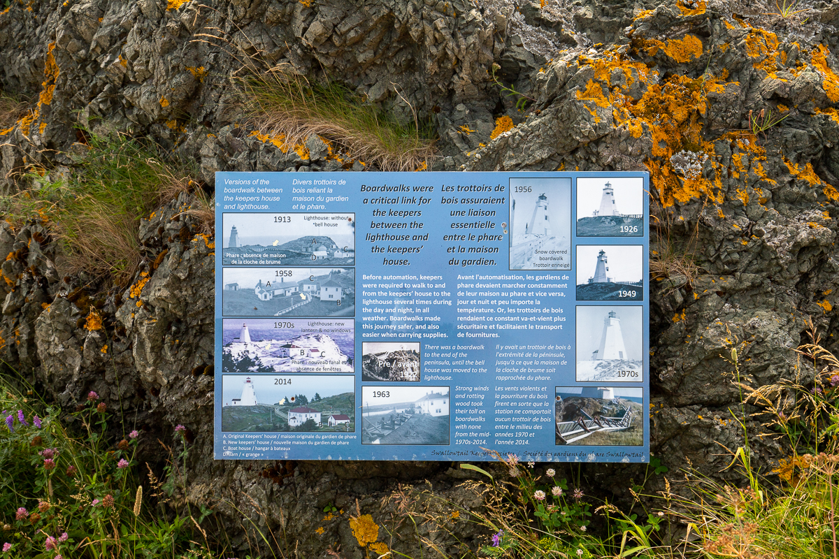
Boardwalks
Boardwalks were a critical link for the keepers between the lighthouse and keepers' house. Before automation, keepers were required to walk to and from the keepers' house to the lighthouse several times during the day and night, in all weather. Boardwalks made this journey safer, and also easier when carrying supplies.
Trail Last Hiked: August 4, 2021.
Page Last Updated: August 15, 2021.